National Register of Historic Places listings in Vermilion County, Illinois
This is a list of the National Register of Historic Places listings in Vermilion County, Illinois.
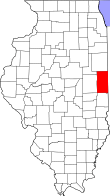
Location of Vermilion County in Illinois
This is intended to be a complete list of the properties and districts on the National Register of Historic Places in Vermilion County, Illinois, United States. Latitude and longitude coordinates are provided for many National Register properties and districts; these locations may be seen together in a map.[1]
There are 13 properties and districts listed on the National Register in the county. Another two properties were once listed but have been removed.
- This National Park Service list is complete through NPS recent listings posted August 14, 2020.[2]
Current listings
| [3] | Name on the Register | Image | Date listed[4] | Location | City or town | Description |
|---|---|---|---|---|---|---|
| 1 | Adams Building | 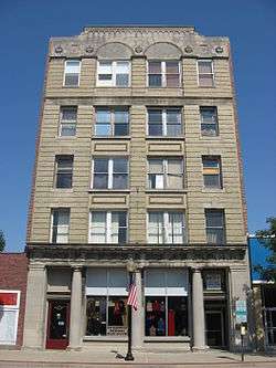 Adams Building |
November 15, 2000 (#00001337) |
139-141 N. Vermilion St. 40°07′39″N 87°37′47″W |
Danville | |
| 2 | Collins Archeological District | 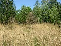 Collins Archeological District |
August 3, 1979 (#79000872) |
West of Lake Mingo at Kennekuk County Park[5] 40°12′28″N 87°44′32″W |
Danville | Part of Kennekuk County Park since the 1970s[6] |
| 3 | Dale Building | 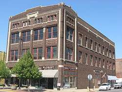 Dale Building |
January 27, 2000 (#99001711) |
101-103 N. Vermilion St. 40°07′35″N 87°37′47″W |
Danville | |
| 4 | Danville Branch, National Home for Disabled Volunteer Soldiers Historic District |  Danville Branch, National Home for Disabled Volunteer Soldiers Historic District |
January 30, 1992 (#91001973) |
1900 and 2000 E. Main St. 40°07′28″N 87°35′15″W |
Danville | |
| 5 | Danville Public Library | 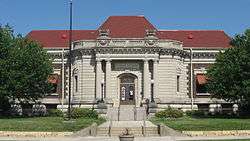 Danville Public Library |
November 30, 1978 (#78003064) |
307 N. Vermilion St. 40°07′46″N 87°37′46″W |
Danville | This building now serves as the Vermilion County War Museum. |
| 6 | First National Bank Building | .jpg) First National Bank Building |
September 13, 2018 (#00001335) |
2-4 N. Vermilion St. 40°07′29″N 87°37′49″W |
Danville | |
| 7 | Fischer Theatre | 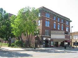 Fischer Theatre |
September 16, 2001 (#01000978) |
158-164 N. Vermilion St. 40°07′41″N 87°37′49″W |
Danville | |
| 8 | Fithian House |  Fithian House |
May 1, 1975 (#75002060) |
116 N. Gilbert St. 40°07′39″N 87°38′10″W |
Danville | |
| 9 | Holland Apartments | 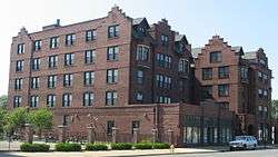 Holland Apartments |
November 16, 1988 (#88002232) |
324-326 N. Vermilion St. 40°07′48″N 87°37′49″W |
Danville | |
| 10 | Hoopes-Cunningham Mansion | 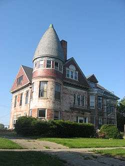 Hoopes-Cunningham Mansion |
September 11, 1985 (#85002307) |
424 E. Penn St. 40°27′59″N 87°39′56″W |
Hoopeston | |
| 11 | Hoopeston Carnegie Public Library |  Hoopeston Carnegie Public Library |
May 9, 2002 (#02000458) |
110 N. Fourth St. 40°28′07″N 87°39′54″W |
Hoopeston | |
| 12 | Stone Arch Bridge | 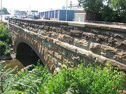 Stone Arch Bridge |
May 16, 1986 (#86001087) |
760-800 E. Main St. 40°07′29″N 87°37′03″W |
Danville | |
| 13 | United States Post Office and Court House |  United States Post Office and Court House |
November 22, 2016 (#16000785) |
201 North Vermilion St. 40°07′42″N 87°37′48″W |
Danville |
Former listing
| [3] | Name on the Register | Image | Date listed | Date removed | Location | City or town | Summary |
|---|---|---|---|---|---|---|---|
| 1 | Building at 210-212 West North Street | Building at 210-212 West North Street |
November 8, 2000 (#00001334) | January 2, 2020 | 210-212 West North St. 40°07′34″N 87°38′00″W |
Danville | Demolished c. 2006.[7] |
| 2 | Temple Building |  Temple Building |
December 1, 2000 (#00001457) | March 14, 2002 | 102-106 N. Vermilion St. 40°07′35″N 87°37′48″W |
Danville | Building demolished by the City of Danville in 2002 |
gollark: > only externallyRidiculous. PotatOS should be able to flash bare-metal PotatoBIOS if it wants to.
gollark: If there was an `os.flashBIOS` you'd need a way to set that from the disk drive *too* I guess, which is a downside.
gollark: Yes, exactly.
gollark: Maybe you could have an `os.flashBIOS` thing instead of making it use a file.
gollark: `shell.allow_startup` wouldn't apply to them, for instance.
See also
| Wikimedia Commons has media related to National Register of Historic Places in Vermilion County, Illinois. |
References
- The latitude and longitude information provided in this table was derived originally from the National Register Information System, which has been found to be fairly accurate for about 99% of listings. Some locations in this table may have been corrected to current GPS standards.
- "National Register of Historic Places: Weekly List Actions". National Park Service, United States Department of the Interior. Retrieved on August 14, 2020.
- Numbers represent an ordering by significant words. Various colorings, defined here, differentiate National Historic Landmarks and historic districts from other NRHP buildings, structures, sites or objects.
- The eight-digit number below each date is the number assigned to each location in the National Register Information System database, which can be viewed by clicking the number.
- Maruszak, Kathleen. National Register of Historic Places Inventory/Nomination: Collins Archeological District. National Park Service, 1977-04, 14.
- "ITARP Annual Report Archived 2013-02-27 at the Wayback Machine, Illinois Transportation Archaeological Research Program, 2009, 30-31. Accessed 2012-05-17.
- "Archived copy" (PDF). Archived from the original (PDF) on 2013-12-24. Retrieved 2014-01-12.CS1 maint: archived copy as title (link)
| Topics | |
|---|---|
| Lists by state |
|
| Lists by insular areas | |
| Lists by associated state | |
| Other areas | |
| Related | |
| |
Municipalities and communities of Vermilion County, Illinois, United States | ||
|---|---|---|
| Cities | Map of Illinois highlighting Vermilion County | |
| Villages | ||
| Townships | ||
| CDP | ||
| Other unincorporated communities | ||
| Footnotes | ‡This populated place also has portions in an adjacent county or counties | |
This article is issued from Wikipedia. The text is licensed under Creative Commons - Attribution - Sharealike. Additional terms may apply for the media files.