National Register of Historic Places listings in Twin Falls County, Idaho
This is a list of the National Register of Historic Places listings in Twin Falls County, Idaho.

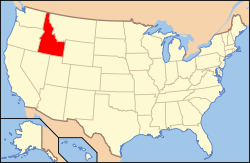
Location of Twin Falls County in Idaho
This is intended to be a complete list of the properties and districts on the National Register of Historic Places in Twin Falls County, Idaho, United States. Latitude and longitude coordinates are provided for many National Register properties and districts; these locations may be seen together in a map.[1]
There are 41 properties and districts listed on the National Register in the county. More may be added; properties and districts nationwide are added to the Register weekly.[2] Another 2 properties were once listed but have been removed.
- This National Park Service list is complete through NPS recent listings posted August 14, 2020.[3]
Current listings
| [4] | Name on the Register[5] | Image | Date listed[6] | Location | City or town | Description |
|---|---|---|---|---|---|---|
| 1 | James Alvis House | May 23, 1980 (#80001335) |
1311 Pole Line Rd. 42°35′32″N 114°27′20″W |
Twin Falls | ||
| 2 | Bickel School | 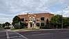 Bickel School |
August 17, 1990 (#90001233) |
607 2nd Ave., E. 42°33′08″N 114°27′41″W |
Twin Falls | |
| 3 | T. P. Bowlby Barn | September 7, 1983 (#83000293) |
Northeast of Buhl 42°37′23″N 114°42′17″W |
Buhl | ||
| 4 | Buhl City Hall | February 8, 1978 (#78001099) |
Broadway and Elm St. 42°36′00″N 114°45′38″W |
Buhl | ||
| 5 | Buhl IOOF Building | 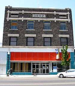 Buhl IOOF Building |
December 27, 1984 (#84000482) |
1014-16 Main St. 42°35′56″N 114°45′35″W |
Buhl | |
| 6 | Caldron Linn |  Caldron Linn |
June 27, 1972 (#72000442) |
2 miles east of Murtaugh 42°29′53″N 114°09′46″W |
Murtaugh | Extends into Jerome County |
| 7 | Cedar Draw School | August 8, 1991 (#91000986) |
4300 N. Rd. between 1900 and 2000 E. 42°37′20″N 114°40′03″W |
Buhl | ||
| 8 | Dau-Webbenhorst Barn | September 7, 1983 (#83000295) |
Southeast of Buhl 42°34′40″N 114°44′22″W |
Buhl | ||
| 9 | Achille Duquesne House | September 23, 1993 (#93000990) |
710 W. Midway 42°34′17″N 114°36′49″W |
Filer | ||
| 10 | Hollister School | August 8, 1991 (#91000984) |
2464 Salmon Ave. 42°21′24″N 114°35′31″W |
Hollister | ||
| 11 | Hotel Buhl | 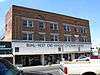 Hotel Buhl |
September 12, 1985 (#85002158) |
1004 Main St. 42°35′56″N 114°45′35″W |
Buhl | |
| 12 | Idaho Power Substation | June 23, 1978 (#78001100) |
Van Buren St. and Filer Ave. 42°34′14″N 114°28′12″W |
Twin Falls | ||
| 13 | Kimberly High School | August 17, 1990 (#90001229) |
141 Center St., W. 42°32′00″N 114°21′55″W |
Kimberly | ||
| 14 | Rudolf Kunze Barn | April 5, 1994 (#83000292) |
Northeast of Buhl 42°35′05″N 114°42′46″W |
Buhl | Gambrel-roofed dairy barn built in 1915. Listed, delisted, relisted. | |
| 15 | Lincoln School |  Lincoln School |
August 17, 1990 (#90001218) |
238 7th St., N. 42°33′43″N 114°28′33″W |
Twin Falls | |
| 16 | Lincoln Street Electric Streetlights | April 27, 1992 (#92000413) |
105, 120, 147, 174, 189, 210, 217, 242, 275, and 290 Lincoln St. 42°33′51″N 114°27′38″W |
Twin Falls | ||
| 17 | Art and Frieda Maxwell Barn | September 7, 1983 (#83000291) |
Southeast of Buhl 42°35′25″N 114°42′36″W |
Buhl | ||
| 18 | Robert McCollum House |  Robert McCollum House |
November 4, 1982 (#82000386) |
708 E. Shoshone St. 42°33′36″N 114°27′48″W |
Twin Falls | |
| 19 | Milner Dam and the Twin Falls Main Canal |  Milner Dam and the Twin Falls Main Canal |
July 10, 1986 (#86001720) |
Twin Falls Main Canal between Murtaugh and Milner Lakes 42°29′58″N 114°04′50″W |
Murtaugh | Extends into Jerome County |
| 20 | Burton Morse House | September 23, 1993 (#93000992) |
136 10th Ave., N. 42°33′45″N 114°27′41″W |
Twin Falls | ||
| 21 | Owsley Bridge | 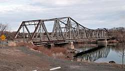 Owsley Bridge |
September 18, 1998 (#98001172) |
Approximately 200 yards north of the junction of old U.S. Route 30 and Bell Rapids Rd. 42°45′52″N 114°53′21″W |
Hagerman | Extends into Gooding County |
| 22 | D. H. Peck House | September 23, 1993 (#93000993) |
207 E. 8th Ave. 42°33′35″N 114°27′40″W |
Twin Falls | ||
| 23 | Pleasant Valley School | August 8, 1991 (#91000985) |
3501 E. 3100 N. 42°26′48″N 114°21′45″W |
Kimberly | ||
| 24 | Pleasant View School | August 8, 1991 (#91000987) |
2500 E. 3600 N. 42°31′12″N 114°33′30″W |
Twin Falls | ||
| 25 | Walter Priebe House | September 23, 1993 (#93000991) |
155 7th Ave. E. 42°33′34″N 114°27′44″W |
Twin Falls | ||
| 26 | Ramona Theater | 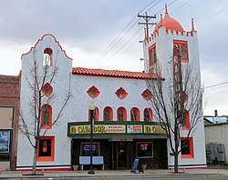 Ramona Theater |
December 22, 1976 (#76000682) |
113 Broadway 42°35′55″N 114°45′31″W |
Buhl | |
| 27 | Rogerson School | December 3, 2019 (#100004759) |
2291 East 1510 North 42°13′00″N 114°35′45″W |
Rogerson | ||
| 28 | Salmon Falls Dam | 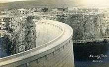 Salmon Falls Dam |
May 15, 2009 (#09000328) |
Three Creek Highway 42°12′44″N 114°44′03″W |
Rogerson | |
| 29 | Henry Schick Barn | September 7, 1983 (#83000290) |
Southeast of Buhl 42°34′46″N 114°42′42″W |
Buhl | ||
| 30 | C. Harvey Smith House | April 3, 1978 (#78001101) |
255 4th Ave., E. 42°33′23″N 114°27′51″W |
Twin Falls | ||
| 31 | Stricker Store and Farm | August 30, 1979 (#79000810) |
North of Rock Creek 42°27′33″N 114°19′16″W |
Twin Falls | ||
| 32 | Toana Freight Wagon Road Historic District | November 29, 2006 (#06001075) |
Generally runs south to north from Nevada-Idaho state line to the Snake River 42°21′40″N 114°52′04″W |
Castleford | ||
| 33 | Twin Falls Bank and Trust Company Building |  Twin Falls Bank and Trust Company Building |
September 4, 1986 (#86002155) |
102 Main Ave. S 42°33′20″N 114°28′08″W |
Twin Falls | |
| 34 | Twin Falls Canal Company Building | 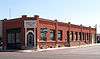 Twin Falls Canal Company Building |
August 30, 1996 (#96000944) |
162 2nd St., W. 42°33′21″N 114°28′17″W |
Twin Falls | |
| 35 | Twin Falls City Park Historic District |  Twin Falls City Park Historic District |
March 30, 1978 (#78001102) |
2nd N., 2nd E., and Shoshone Sts., 4th and 6th Aves. 42°33′31″N 114°27′57″W |
Twin Falls | |
| 36 | Twin Falls Downtown Historic District | 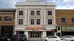 Twin Falls Downtown Historic District |
February 4, 2000 (#00000035) |
Roughly bounded by 2nd Ave., N., 2nd St., E., 2nd St., W., 2nd St., S., 3rd Ave., S., and 3rd St., W. 42°33′23″N 114°28′14″W |
Twin Falls | |
| 37 | Twin Falls Milling and Elevator Company Warehouse |  Twin Falls Milling and Elevator Company Warehouse |
August 31, 1995 (#95001059) |
516 2nd St., S. 42°33′08″N 114°28′23″W |
Twin Falls | |
| 38 | Twin Falls Original Townsite Residential Historic District | 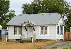 Twin Falls Original Townsite Residential Historic District |
November 30, 2001 (#01001306) |
Roughly bounded by Blue Lakes Ave., Addison Ave., 2nd Ave. E, and 2nd Ave. W 42°33′36″N 114°28′12″W |
Twin Falls | |
| 39 | Twin Falls Warehouse Historic District |  Twin Falls Warehouse Historic District |
January 15, 1997 (#96001592) |
Roughly bounded by 2nd Ave., 4th St., S. and W., and Minidoka Ave. 42°33′10″N 114°28′23″W |
Twin Falls | |
| 40 | Union School | March 20, 2003 (#03000123) |
21337 U.S. Route 30 42°33′49″N 114°32′56″W |
Filer | ||
| 41 | US Post Office-Buhl Main | 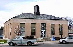 US Post Office-Buhl Main |
March 16, 1989 (#89000130) |
830 Main 42°36′00″N 114°45′28″W |
Buhl |
Former listing
| [4] | Name on the Register | Image | Date listed | Date removed | Location | City or town | Summary |
|---|---|---|---|---|---|---|---|
| 1 | Alfred Carlson Barn | September 7, 1983 (#83000296) | October 16, 1989 | NE of Buhl |
Buhl vicinity | ||
| 2 | Gustave Kunze Barn | 1983 (#83000294) | March 22, 1994 | SE of Buhl |
Buhl vicinity |
gollark: Do you want me to implement a separate computer name system?
gollark: Computer name isn't label.
gollark: And Windows doesn't let you, say, randomly flip values in physical memory.
gollark: It's not essential.
gollark: You can change the label, just not clear it.
See also
| Wikimedia Commons has media related to National Register of Historic Places in Twin Falls County, Idaho. |
Notes
References
- The latitude and longitude information provided in this table was derived originally from the National Register Information System, which has been found to be fairly accurate for about 99% of listings. Some locations in this table may have been corrected to current GPS standards.
- "National Register of Historic Places: Weekly List Actions". National Park Service. Retrieved March 29, 2009.
- "National Register of Historic Places: Weekly List Actions". National Park Service, United States Department of the Interior. Retrieved on August 14, 2020.
- Numbers represent an ordering by significant words. Various colorings, defined here, differentiate National Historic Landmarks and historic districts from other NRHP buildings, structures, sites or objects.
- "National Register Information System". National Register of Historic Places. National Park Service. April 24, 2008.
- The eight-digit number below each date is the number assigned to each location in the National Register Information System database, which can be viewed by clicking the number.
| Topics | |
|---|---|
| Lists by state |
|
| Lists by insular areas | |
| Lists by associated state | |
| Other areas | |
| Related | |
| |
Municipalities and communities of Twin Falls County, Idaho, United States | ||
|---|---|---|
| Cities | Map of Idaho highlighting Twin Falls County | |
| Unincorporated community | ||
This article is issued from Wikipedia. The text is licensed under Creative Commons - Attribution - Sharealike. Additional terms may apply for the media files.