National Register of Historic Places listings in Turner County, South Dakota
This is a list of the National Register of Historic Places listings in Turner County, South Dakota.
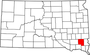
Location of Turner County in South Dakota
This is intended to be a complete list of the properties and districts on the National Register of Historic Places in Turner County, South Dakota, United States. The locations of National Register properties and districts for which the latitude and longitude coordinates are included below, may be seen in a map.[1]
There are 30 properties and districts listed on the National Register in the county. Another 2 properties were once listed but have since been removed.
- This National Park Service list is complete through NPS recent listings posted August 14, 2020.[2]
Current listings
| [3] | Name on the Register[4] | Image | Date listed[5] | Location | City or town | Description |
|---|---|---|---|---|---|---|
| 1 | Archeological Site 39TU5 | February 23, 1984 (#84003417) |
Address Restricted |
Freeman | ||
| 2 | Bones Hereford Ranch Sale Barn |  Bones Hereford Ranch Sale Barn |
December 14, 1995 (#95001472) |
45874 268th Street 43°29′55″N 97°01′17″W |
Parker | |
| 3 | Bridge No. 63-137-090-Parker | 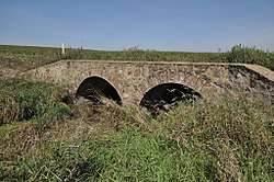 Bridge No. 63-137-090-Parker |
August 5, 1999 (#99000951) |
County Road 22 over an unnamed stream 43°22′24″N 97°07′44″W |
Parker | |
| 4 | Brough-Martinson House |  Brough-Martinson House |
March 30, 1978 (#78002570) |
Off Highway 19 43°16′55″N 97°05′24″W |
Hurley | |
| 5 | Centerville Township Bridge Number S-18 | October 30, 2000 (#00001216) |
294th Street 43°07′37″N 97°02′20″W |
Centerville | ||
| 6 | Childstown Township Bridge Number S-15 | October 30, 2000 (#00001217) |
282nd Street 43°17′58″N 97°12′40″W |
Childstown | ||
| 7 | Dalton Township Bridge | December 9, 1999 (#99001439) |
Local road over an unnamed stream 43°26′59″N 97°16′49″W |
Marion | ||
| 8 | Daneville Township Bridge No. E-26 | December 9, 1999 (#99001441) |
Local road over an unnamed stream 43°06′04″N 97°03′43″W |
Viborg | ||
| 9 | Farrar House |  Farrar House |
March 21, 1978 (#78002571) |
Off Highway 19 43°17′07″N 97°05′25″W |
Hurley | |
| 10 | Germantown Township Bridge S-29 | October 30, 2000 (#00001219) |
278th Street 43°21′32″N 97°00′29″W |
Germantown | ||
| 11 | Glud Theatre | June 8, 2007 (#07000530) |
119 North Main Street 43°10′23″N 97°04′55″W |
Viborg | ||
| 12 | Dr. Harry S. Graves House |  Dr. Harry S. Graves House |
March 21, 1978 (#78002572) |
Center Avenue and Monroe Street 43°16′59″N 97°05′26″W |
Hurley | |
| 13 | Tenus Isaac Gunderson House | 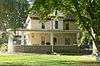 Tenus Isaac Gunderson House |
January 28, 2004 (#03001534) |
1041 Washington 43°07′12″N 96°57′50″W |
Centerville | |
| 14 | William Higinbotham House | 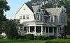 William Higinbotham House |
June 6, 2001 (#01000635) |
511 Main Street 43°07′01″N 96°57′20″W |
Centerville | |
| 15 | Chandler Gray and Mary Abbie Newhall House and Homestead Shack | June 9, 1992 (#92000682) |
5 miles west and 4.5 miles south of Parker 43°20′19″N 97°14′22″W |
Parker | ||
| 16 | Parker Masonic Hall | 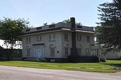 Parker Masonic Hall |
July 28, 2004 (#04000761) |
130 South Cherry Avenue 43°23′55″N 97°08′03″W |
Parker | |
| 17 | Salem Township Bridge Number E-1 | October 30, 2000 (#00001218) |
446th Street 43°14′52″N 97°16′45″W |
Salem | ||
| 18 | South Dakota Department of Transportation Bridge No. 63-016-150 | November 19, 1999 (#99001342) |
Local road over an unnamed creek 43°17′06″N 97°22′00″W |
Marion | ||
| 19 | South Dakota Department of Transportation Bridge No. 63-052-030 | September 29, 1999 (#99001217) |
Local road over the West Fork of the Vermillion River 43°27′32″N 97°17′41″W |
Marion | ||
| 20 | South Dakota Department of Transportation Bridge No. 63-132-040 | 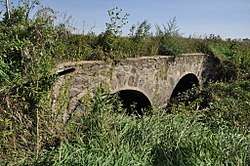 South Dakota Department of Transportation Bridge No. 63-132-040 |
September 29, 1999 (#99001215) |
Local road over an unnamed stream 43°26′42″N 97°08′09″W |
Parker | |
| 21 | South Dakota Department of Transportation Bridge No. 63-160-056 | 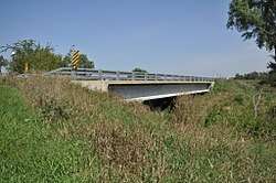 South Dakota Department of Transportation Bridge No. 63-160-056 |
November 19, 1999 (#99001343) |
Local road over the East Fork of the Vermillion River 43°25′21″N 97°04′58″W |
Parker | Replaced between 2004 and 2007 |
| 22 | South Dakota Department of Transportation Bridge No. 63-197-130 | September 29, 1999 (#99001210) |
Local road over the East Fork of the Vermillion River 43°19′00″N 97°00′43″W |
Davis | ||
| 23 | South Dakota Department of Transportation Bridge No. 63-198-181 | September 29, 1999 (#99001212) |
Local road over the East Fork of the Vermillion River 43°14′31″N 97°00′12″W |
Davis | Replace between 2006 and 2008[6] | |
| 24 | South Dakota Department of Transportation Bridge No. 63-210-282 | 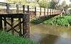 South Dakota Department of Transportation Bridge No. 63-210-282 |
September 29, 1999 (#99001216) |
Local road over the East Fork of the Vermillion River 43°05′46″N 96°58′54″W |
Centerville | Apparently no longer extant[7] |
| 25 | Spring Valley Township Bridge No. E-31 | December 9, 1999 (#99001440) |
Local road over an unnamed stream 43°10′27″N 97°15′33″W |
Viborg | ||
| 26 | Thielman-Stoddard House |  Thielman-Stoddard House |
August 3, 1979 (#79003691) |
132 First Street 43°23′49″N 97°08′17″W |
Parker | |
| 27 | James S. Thomson House | 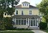 James S. Thomson House |
August 18, 1983 (#83003021) |
1121 Washington St. 43°07′12″N 96°57′54″W |
Centerville | |
| 28 | Turner Township Bridge No. SE-18 |  Turner Township Bridge No. SE-18 |
November 15, 2000 (#00001351) |
459th St. 43°12′48″N 97°01′21″W |
Centerville | |
| 29 | Jacob Weins House-Barn | August 13, 1984 (#84003419) |
Northwestern corner of the southeastern quadrant of Section 14, T99N, R55W[8] 43°23′34″N 97°18′27″W |
Marion | ||
| 30 | Wek Farmstead | January 28, 2004 (#03001535) |
44227 288th St. 43°12′44″N 97°21′10″W |
Freeman |
Former listings
| [3] | Name on the Register | Image | Date listed | Date removed | Location | City or town | Summary |
|---|---|---|---|---|---|---|---|
| 1 | I.O.O.F. Hall, Hurley Lodge No. 75 | July 1, 1982 (#82003944) | January 12, 1988 | Center Ave. |
Hurley | ||
| 2 | South Dakota Department of Transportation Bridge No. 63-177-160 | September 29, 1999 (#99001211) | March 26, 2008 | Local Road over Turkey Ridge Creek |
Hurley | ||
| 3 | South Dakota Department of Transportation Bridge No. 63-186-020 | September 29, 1999 (#99001214) | March 26, 2008 | Local Road over Long Creek |
Parker |
gollark: Also, it is planned to and currently does store all data (except file uploads, I guess, when/if™ that is added) in a single SQLite3 database.
gollark: Another thing I thought would be neat is some limited scripting support, or at least the ability to say "include the content of this page here" or "show all pages matching this query". But that would be very hard.
gollark: One thing I thought would be neat would be a visualization of the links between pages, but that would be hard.
gollark: I mean, "would" is inaccurate, the system already implements this, except tags.
gollark: Also, because I prefer this, pages would be indexed entirely by a canonical name and there would be no hierarchy, merely tags.
See also
| Wikimedia Commons has media related to National Register of Historic Places in Turner County, South Dakota. |
References
- The latitude and longitude information provided in this table was derived originally from the National Register Information System, which has been found to be fairly accurate for about 99% of listings. Some locations in this table may have been corrected to current GPS standards.
- "National Register of Historic Places: Weekly List Actions". National Park Service, United States Department of the Interior. Retrieved on August 14, 2020.
- Numbers represent an ordering by significant words. Various colorings, defined here, differentiate National Historic Landmarks and historic districts from other NRHP buildings, structures, sites or objects.
- "National Register Information System". National Register of Historic Places. National Park Service. April 24, 2008.
- The eight-digit number below each date is the number assigned to each location in the National Register Information System database, which can be viewed by clicking the number.
- See 2015 photos.
- Location derived from its NRHP nomination form; the NRIS lists it as "Address Restricted"
| Topics | |
|---|---|
| Lists by state |
|
| Lists by insular areas | |
| Lists by associated state | |
| Other areas | |
| Related | |
| |
Municipalities and communities of Turner County, South Dakota, United States | ||
|---|---|---|
| Cities | | |
| Towns | ||
| Townships | ||
| Unincorporated community | ||
| Footnotes | ‡This populated place also has portions in an adjacent county or counties | |
This article is issued from Wikipedia. The text is licensed under Creative Commons - Attribution - Sharealike. Additional terms may apply for the media files.