National Register of Historic Places listings in Tazewell County, Illinois
This is a list of the National Register of Historic Places listings in Tazewell County, Illinois.
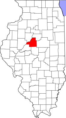
Location of Tazewell County in Illinois
This is intended to be a complete list of the properties and districts on the National Register of Historic Places in Tazewell County, Illinois, United States. Latitude and longitude coordinates are provided for many National Register properties and districts; these locations may be seen together in a map.[1]
There are 17 properties and districts listed on the National Register in the county.
- This National Park Service list is complete through NPS recent listings posted August 14, 2020.[2]
Current listings
| [3] | Name on the Register | Image | Date listed[4] | Location | City or town | Description |
|---|---|---|---|---|---|---|
| 1 | Allentown Union Hall | _from_SE_2.jpg) Allentown Union Hall |
August 12, 1988 (#88001228) |
2 mi. E of IL 121 40°33′19″N 89°23′50″W |
Allentown | |
| 2 | Ayer Public Library | 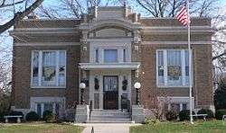 Ayer Public Library |
November 12, 1998 (#98001352) |
200 Locust St. 40°22′27″N 89°32′49″W |
Delavan | |
| 3 | Cemetery Road Bridge | 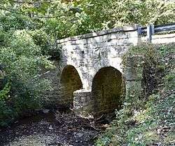 Cemetery Road Bridge |
May 20, 1998 (#98000467) |
Candlewood Dr. within Glendale Cemetery 40°41′51″N 89°24′41″W |
Washington | |
| 4 | Clear Lake Site | November 28, 1978 (#78001171) |
Junction of 1200E and 2600N in Sand Ridge State Park[5] 40°26′08″N 89°54′00″W |
Manito | Extends into Mason County | |
| 5 | Delavan Commercial Historic District | 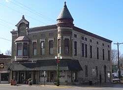 Delavan Commercial Historic District |
November 14, 1991 (#91001687) |
307, 309-324, 400, 401, 404-410, 412, and 414 Locust St. 40°22′20″N 89°32′50″W |
Delavan | |
| 6 | Dement-Zinser House | 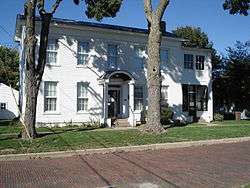 Dement-Zinser House |
November 27, 2002 (#02001411) |
105 Zinser Place 40°42′16″N 89°24′26″W |
Washington | |
| 7 | Denhart Bank Building | 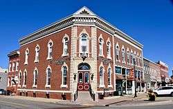 Denhart Bank Building |
August 12, 2005 (#05000874) |
101 Washington Square 40°42′14″N 89°24′24″W |
Washington | |
| 8 | Farm Creek Section | 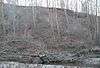 Farm Creek Section |
February 6, 1992 (#91002039) |
S side of Farm Creek 40°40′38″N 89°29′23″W |
East Peoria | |
| 9 | Carl Herget Mansion | 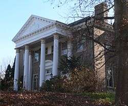 Carl Herget Mansion |
August 18, 1992 (#92001005) |
420 Washington St. 40°33′52″N 89°38′47″W |
Pekin | |
| 10 | Illinois Traction System Mackinaw Depot | Illinois Traction System Mackinaw Depot |
November 30, 1978 (#78001192) |
301 N. Main St.[6] 40°32′22″N 89°21′33″W |
Mackinaw | |
| 11 | North Eighth Street Plaza | 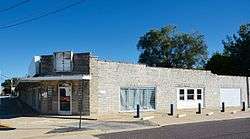 North Eighth Street Plaza |
May 18, 2015 (#15000226) |
1500-1532 N. 8th St. 40°34′53″N 89°38′27″W |
Pekin | |
| 12 | Pekin Federal Building | 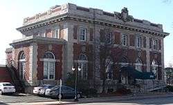 Pekin Federal Building |
October 9, 1980 (#80001412) |
334 Elizabeth St. 40°34′08″N 89°38′55″W |
Pekin | |
| 13 | Peoria Lock and Dam Historic District | Peoria Lock and Dam Historic District |
March 10, 2004 (#04000169) |
1071 Wesley Rd. 40°37′55″N 89°37′28″W |
Creve Coeur | |
| 14 | St. Louis, Peoria and Northern Railroad Depot | St. Louis, Peoria and Northern Railroad Depot |
December 6, 2004 (#04001305) |
1900 block of Broadway St.[7] 40°34′02″N 89°37′24″W |
Pekin | |
| 15 | Tazewell County Courthouse | 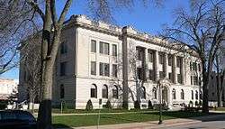 Tazewell County Courthouse |
November 14, 1985 (#85002837) |
Court St. between Capitol and Fourth Sts. 40°34′09″N 89°38′52″W |
Pekin | |
| 16 | Third Street Bridge | Third Street Bridge |
May 20, 1999 (#99000586) |
Third St., bet. Pine and Elm Sts. 40°22′25″N 89°32′41″W |
Delavan | |
| 17 | Waltmire Bridge | _from_SW_2.jpg) Waltmire Bridge |
February 5, 1999 (#99000112) |
Locust Rd. over Mackinaw River, approx. 4.9 mi. S of Tremont 40°26′57″N 89°29′31″W |
Tremont |
Former listing
| [3] | Name on the Register | Image | Date listed | Date removed | Location | City or town | Summary |
|---|---|---|---|---|---|---|---|
| 1 | Pekin Theatre | October 12, 1982 (#82002601) | July 30, 1987 | 21-29 S. Capitol St. |
Pekin |
gollark: 🐝<:bees:724389994663247974>
gollark: Why not just use an osmarks.tk collaboration space™ on my raspberry pi™?
gollark: yes.
gollark: Maybe try and get rootaccess™ using hackerization™ and run haskell properly?
gollark: To some extent, the internet's culture of free expression is going away, and being replaced with "please pick from this list of acceptable political views to use [any large platform]".
References
- The latitude and longitude information provided in this table was derived originally from the National Register Information System, which has been found to be fairly accurate for about 99% of listings. Some locations in this table may have been corrected to current GPS standards.
- "National Register of Historic Places: Weekly List Actions". National Park Service, United States Department of the Interior. Retrieved on August 14, 2020.
- Numbers represent an ordering by significant words. Various colorings, defined here, differentiate National Historic Landmarks and historic districts from other NRHP buildings, structures, sites or objects.
- The eight-digit number below each date is the number assigned to each location in the National Register Information System database, which can be viewed by clicking the number.
- Maruszak, Kathleen. National Register of Historic Places Inventory/Nomination: Clear Lake Site. National Park Service, 1977-01, 3.
- Address visible in this photo
- Moved ca. 2006 from 1400 block to 1900 block of Broadway; see Harris, Sharon Woods, "Train depot renovations to begin", Pekin Times, 2011-12-02, retrieved 2011-12-07.
See also
| Wikimedia Commons has media related to National Register of Historic Places in Tazewell County, Illinois. |
- List of National Historic Landmarks in Illinois
- National Register of Historic Places listings in Illinois
| Topics | |
|---|---|
| Lists by state |
|
| Lists by insular areas | |
| Lists by associated state | |
| Other areas | |
| Related | |
| |
This article is issued from Wikipedia. The text is licensed under Creative Commons - Attribution - Sharealike. Additional terms may apply for the media files.