National Register of Historic Places listings in Scotts Bluff County, Nebraska
This is a list of the National Register of Historic Places listings in Scotts Bluff County, Nebraska.
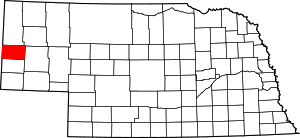
Location of Scotts Bluff County in Nebraska
This is intended to be a complete list of the properties and districts on the National Register of Historic Places in Scotts Bluff County, Nebraska, United States. The locations of National Register properties and districts for which the latitude and longitude coordinates are included below, may be seen in a map.[1]
There are 21 properties and districts listed on the National Register in the county, including 2 National Historic Landmarks.
- This National Park Service list is complete through NPS recent listings posted August 14, 2020.[2]
Current listings
| [3] | Name on the Register | Image | Date listed[4] | Location | City or town | Description |
|---|---|---|---|---|---|---|
| 1 | Fontenelle Apartment House | _from_E_1.JPG) Fontenelle Apartment House |
July 23, 1998 (#98000891) |
1424 4th Ave. 41°51′40″N 103°39′27″W |
Scottsbluff | |
| 2 | Fort Mitchell Site | 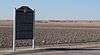 Fort Mitchell Site |
June 7, 1978 (#78001713) |
Southwest of Scottsbluff[5] 41°50′30″N 103°43′50″W |
Scottsbluff | |
| 3 | Gering Courier Building | 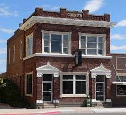 Gering Courier Building |
October 15, 2004 (#04000799) |
1428 10th St. 41°49′23″N 103°39′34″W |
Gering | |
| 4 | Henry State Aid Bridges | 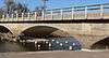 Henry State Aid Bridges |
June 29, 1992 (#92000732) |
North Platte River south of Henry 41°59′27″N 104°02′50″W |
Henry | |
| 5 | Interstate Canal Bridge | _old_bridge_2.JPG) Interstate Canal Bridge |
June 29, 1992 (#92000731) |
County road over Interstate Canal, 9.3 miles north of Scottsbluff 41°59′50″N 103°38′18″W |
Scottsbluff | |
| 6 | Knorr-Holden Continuous Corn Plot | 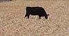 Knorr-Holden Continuous Corn Plot |
June 11, 1992 (#92000703) |
Scottsbluff Experiment Station, on Experiment Farm Road about a mile and a half west of Nebraska Highway 71, north of Scottsbluff 41°56′39″N 103°42′01″W |
Scottsbluff | |
| 7 | Lincoln Hotel | _from_NW_2.JPG) Lincoln Hotel |
March 5, 1998 (#98000187) |
1421 Broadway 41°51′40″N 103°39′43″W |
Scottsbluff | |
| 8 | Marquis Opera House | _from_SW_3.JPG) Marquis Opera House |
October 10, 1985 (#85003103) |
1601-1603 Broadway 41°51′45″N 103°39′43″W |
Scottsbluff | |
| 9 | Midwest Theater | 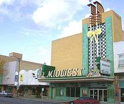 Midwest Theater |
July 3, 1997 (#97000728) |
1707 Broadway 41°51′49″N 103°39′44″W |
Scottsbluff | |
| 10 | M.B. Quivey House | _from_E_1.JPG) M.B. Quivey House |
March 24, 1983 (#83001105) |
1462 19th Ave. 41°56′33″N 103°48′50″W |
Mitchell | |
| 11 | Robidoux Pass | 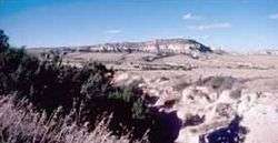 Robidoux Pass |
October 15, 1966 (#66000450) |
9 miles west of Gering 41°48′32″N 103°50′12″W |
Gering | |
| 12 | Saddle Club | Saddle Club |
December 27, 2007 (#07001324) |
2000 W. Overland 41°51′30″N 103°41′32″W |
Scottsbluff | |
| 13 | Sandford Hall | Sandford Hall |
July 9, 1997 (#97000771) |
130625 County Road E 41°56′25″N 103°49′19″W |
Mitchell | |
| 14 | Scotts Bluff County Courthouse | 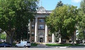 Scotts Bluff County Courthouse |
January 10, 1990 (#89002230) |
10th and Q Sts. 41°49′35″N 103°39′37″W |
Gering | |
| 15 | Scotts Bluff National Monument | 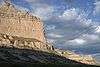 Scotts Bluff National Monument |
October 15, 1966 (#66000117) |
3 miles west of Gering on Nebraska Highway 92 41°50′03″N 103°42′24″W |
Gering | |
| 16 | Scottsbluff Carnegie Library | 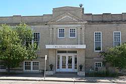 Scottsbluff Carnegie Library |
September 3, 1981 (#81000373) |
106 E. 18th St. 41°51′51″N 103°39′38″W |
Scottsbluff | |
| 17 | Signal Butte | 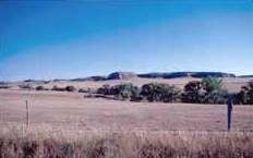 Signal Butte |
October 15, 1966 (#66000452) |
West of Gering[6] 41°47′50″N 103°54′24″W |
Gering | |
| 18 | Severin Sorensen House | _from_SW_1.JPG) Severin Sorensen House |
March 31, 1983 (#83001106) |
2345 17th St. 41°49′56″N 103°40′14″W |
Gering | |
| 19 | Tri-State Land Company Headquarters Building | _from_SW_1.JPG) Tri-State Land Company Headquarters Building |
January 25, 1997 (#96001615) |
13 W. Overland St. 41°51′34″N 103°39′48″W |
Scottsbluff | |
| 20 | US Post Office-Scottsbluff | 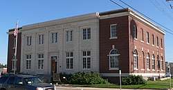 US Post Office-Scottsbluff |
October 5, 1989 (#89001462) |
120 E. 16th St. 41°51′44″N 103°39′35″W |
Scottsbluff | |
| 21 | Western Public Service Building | 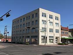 Western Public Service Building |
October 15, 2004 (#04000798) |
1721 Broadway 41°51′51″N 103°39′43″W |
Scottsbluff |
gollark: The PinePhone will possibly be able to run Android apps via an emulator.
gollark: To be fair though, the actual apps aren't electron, they're... react native?
gollark: i. e. a bloated browser with some native interfaces.
gollark: I basically want a browser, calling and texts, so meh.
gollark: My current phone is dying and the battery is not replaceable, so I will probably try and obtain a pinephone if they ship to the UK.
See also
| Wikimedia Commons has media related to National Register of Historic Places in Scotts Bluff County, Nebraska. |
References
- The latitude and longitude information provided in this table was derived originally from the National Register Information System, which has been found to be fairly accurate for about 99% of listings. Some locations in this table may have been corrected to current GPS standards.
- "National Register of Historic Places: Weekly List Actions". National Park Service, United States Department of the Interior. Retrieved on August 14, 2020.
- Numbers represent an ordering by significant words. Various colorings, defined here, differentiate National Historic Landmarks and historic districts from other NRHP buildings, structures, sites or objects.
- The eight-digit number below each date is the number assigned to each location in the National Register Information System database, which can be viewed by clicking the number.
- Location derived from its GNIS feature record; the NRIS lists the site as "Address Restricted"
- Location derived from its GNIS entry; the NRIS lists it as "Address Restricted"
| Topics | |
|---|---|
| Lists by state |
|
| Lists by insular areas | |
| Lists by associated state | |
| Other areas | |
| Related | |
| |
Municipalities and communities of Scotts Bluff County, Nebraska, United States | ||
|---|---|---|
| Cities | Map of Nebraska highlighting Scotts Bluff County | |
| Villages | ||
| Unincorporated communities | ||
This article is issued from Wikipedia. The text is licensed under Creative Commons - Attribution - Sharealike. Additional terms may apply for the media files.