National Register of Historic Places listings in Sanders County, Montana
This is a list of the National Register of Historic Places listings in Sanders County, Montana. It is intended to be a complete list of the properties and districts on the National Register of Historic Places in Sanders County, Montana, United States. The locations of National Register properties and districts for which the latitude and longitude coordinates are included below, may be seen in a map.[1]

Location of Sanders County in Montana
There are 22 properties and districts listed on the National Register in the county.
- This National Park Service list is complete through NPS recent listings posted August 14, 2020.[2]
Listings county-wide
| [3] | Name on the Register | Image | Date listed[4] | Location | City or town | Description |
|---|---|---|---|---|---|---|
| 1 | Ainsworth House | 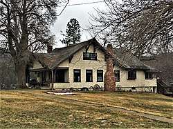 Ainsworth House |
October 7, 1986 (#86002771) |
911 Maiden Ln. 47°35′43″N 115°21′19″W |
Thompson Falls | |
| 2 | Bedard House | 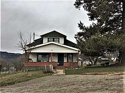 Bedard House |
October 7, 1986 (#86002783) |
207 Spruce St. 47°35′50″N 115°20′43″W |
Thompson Falls | |
| 3 | Bull River Guard Station | June 27, 1990 (#90000990) |
On the banks of the Bull River near its confluence with the E. Fork Bull River in the Kootenai National Forest 48°06′24″N 115°46′40″W |
Noxon | ||
| 4 | Cougar Peak Lookout | August 6, 2018 (#100002774) |
Plains / Thompson Falls Ranger District, Lolo NF 47°44′41″N 115°23′01″W |
Thompson Falls vicinity | ||
| 5 | Gem Saloon | 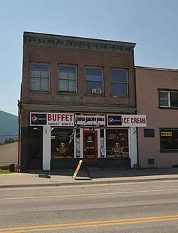 Gem Saloon |
October 7, 1986 (#86002767) |
808 Main St. 47°35′40″N 115°20′45″W |
Thompson Falls | |
| 6 | Grandchamp House | 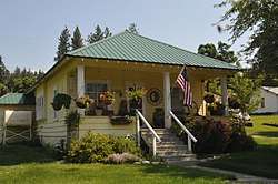 Grandchamp House |
October 7, 1986 (#86002776) |
1012 Preston Ave. 47°35′51″N 115°21′10″W |
Thompson Falls | |
| 7 | Griffen House | 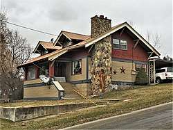 Griffen House |
October 7, 1986 (#86002779) |
205 Gallatin St. 47°35′53″N 115°21′04″W |
Thompson Falls | |
| 8 | House at 112 Park Street | 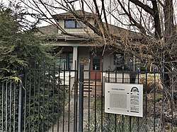 House at 112 Park Street |
October 7, 1986 (#86002778) |
112 Park St. 47°35′51″N 115°21′07″W |
Thompson Falls | |
| 9 | House at 916 Preston Avenue | October 7, 1986 (#86002777) |
916 Preston Ave. 47°35′49″N 115°21′07″W |
Thompson Falls | ||
| 10 | Hoyt House | 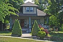 Hoyt House |
October 7, 1986 (#86002780) |
204 Gallatin St. 47°35′52″N 115°20′59″W |
Thompson Falls | |
| 11 | IOOF Lodge | 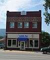 IOOF Lodge |
October 7, 1986 (#86002761) |
520 Main St. 47°35′35″N 115°20′31″W |
Thompson Falls | |
| 12 | Norby House | October 7, 1986 (#86002775) |
13 Pond St. 47°35′48″N 115°21′19″W |
Thompson Falls | ||
| 13 | Northern Pacific Warehouse |  Northern Pacific Warehouse |
October 7, 1986 (#86002785) |
Bounded by Preston Ave. and Main St. along the Burlington Northern right-of-way 47°35′42″N 115°20′33″W |
Thompson Falls | |
| 14 | Preston House | 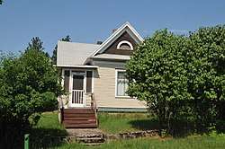 Preston House |
October 7, 1986 (#86002784) |
205 Ferry St. 47°35′45″N 115°20′30″W |
Thompson Falls | |
| 15 | Rinard House |  Rinard House |
October 7, 1986 (#86002782) |
210 Jefferson St. 47°35′50″N 115°20′50″W |
Thompson Falls | |
| 16 | Sanders County Jail | 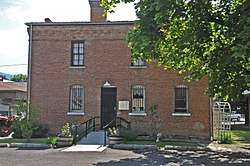 Sanders County Jail |
October 7, 1986 (#86002774) |
Madison and Maiden Lane 47°35′42″N 115°21′00″W |
Thompson Falls | |
| 17 | Symes Hotel | 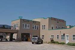 Symes Hotel |
November 12, 1998 (#98001363) |
209 N. Wall St. 47°36′37″N 114°40′16″W |
Hot Springs | |
| 18 | Thayer House | 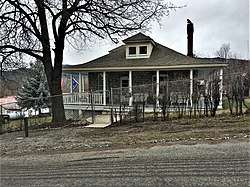 Thayer House |
December 22, 1986 (#86002781) |
109 Jefferson St. 47°35′49″N 115°20′54″W |
Thompson Falls | |
| 19 | Thompson Falls Hydroelectric Dam Historic District | 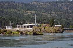 Thompson Falls Hydroelectric Dam Historic District |
October 7, 1986 (#86002756) |
Alternate U.S. Route 10 at the Clark Fork River within the northwestern part of Thompson Falls 47°35′38″N 115°21′25″W |
Thompson Falls | |
| 20 | Tourist Hotel | 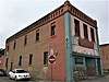 Tourist Hotel |
October 7, 1986 (#86002765) |
101 Main St. 47°35′40″N 115°20′41″W |
Thompson Falls | |
| 21 | Ward Hotel | 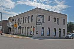 Ward Hotel |
December 22, 1986 (#86002769) |
919 Main St. 47°35′41″N 115°20′48″W |
Thompson Falls | |
| 22 | Weber's Store | 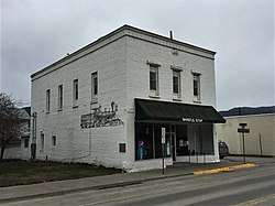 Weber's Store |
October 7, 1986 (#86002763) |
510 Main St. 47°35′37″N 115°20′34″W |
Thompson Falls |
gollark: Yes, but by how much? Are people making extremely small gender shifts constantly? Do genders change every time electrons move in the brain (by essentially zero amount?)?!!!!?
gollark: Perhaps we should have labels for first and second derivative of gender on various axes.
gollark: They are moving through genderspace over time, yes, I said so.
gollark: Brains don't operate at infinite speed. I guess it depends on what you count as a gender change.
gollark: However³, yes, multiple personality weirdness also.
See also
| Wikimedia Commons has media related to National Register of Historic Places in Sanders County, Montana. |
References
- The latitude and longitude information provided in this table was derived originally from the National Register Information System, which has been found to be fairly accurate for about 99% of listings. Some locations in this table may have been corrected to current GPS standards.
- "National Register of Historic Places: Weekly List Actions". National Park Service, United States Department of the Interior. Retrieved on August 14, 2020.
- Numbers represent an ordering by significant words. Various colorings, defined here, differentiate National Historic Landmarks and historic districts from other NRHP buildings, structures, sites or objects.
- The eight-digit number below each date is the number assigned to each location in the National Register Information System database, which can be viewed by clicking the number.
| Topics | |
|---|---|
| Lists by state |
|
| Lists by insular areas | |
| Lists by associated state | |
| Other areas | |
| Related | |
| |
Municipalities and communities of Sanders County, Montana, United States | ||
|---|---|---|
| City | Sanders County map | |
| Towns | ||
| CDPs | ||
| Indian reservation | ||
| Footnotes | ‡This populated place also has portions in an adjacent county or counties | |
This article is issued from Wikipedia. The text is licensed under Creative Commons - Attribution - Sharealike. Additional terms may apply for the media files.