National Register of Historic Places listings in McPherson County, South Dakota
This is a list of the National Register of Historic Places listings in McPherson County, South Dakota.
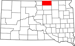
Location of McPherson County in South Dakota
This is intended to be a complete list of the properties on the National Register of Historic Places in McPherson County, South Dakota, United States. The locations of National Register properties for which the latitude and longitude coordinates are included below, may be seen in a map.[1]
There are 4 properties listed on the National Register in the county.
- This National Park Service list is complete through NPS recent listings posted August 14, 2020.[2]
Current listings
| [3] | Name on the Register[4] | Image | Date listed[5] | Location | City or town | Description |
|---|---|---|---|---|---|---|
| 1 | Archeological Site No. 39MP3 |  Archeological Site No. 39MP3 |
August 6, 1993 (#93000795) |
Address Restricted |
Long Lake | |
| 2 | Amos Hoffman House | August 13, 1986 (#86001476) |
Highway 10 45°43′39″N 98°56′54″W |
Leola | ||
| 3 | McPherson County Courthouse | 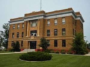 McPherson County Courthouse |
November 3, 1986 (#86003020) |
Highway 10 45°43′24″N 98°56′22″W |
Leola | |
| 4 | Peter Wittmayer House-Barn | August 13, 1984 (#84003344) |
Southwestern quarter of the northwestern quadrant of Section 13, T127N, R71W[6] 45°49′17″N 99°21′37″W |
Eureka |
Former listings
| [3] | Name on the Register | Image | Date listed | Date removed | Location | City or town | Summary |
|---|---|---|---|---|---|---|---|
| 1 | Eureka Lutheran College | October 25, 1990 (#90001643) | December 28, 2000 | 301 Fourth St. |
Eureka | ||
| 2 | Leola Post Office | June 22, 2005 (#05000627) | October 29, 2008 | 741 Sherman Street |
Leola |
gollark: This is true, but in general.
gollark: Yes, I feel like the bad part is the lying mostly.
gollark: Although I *probably* haven't isolated my Discord-y profiles from my real-life information as well as I should, oops!
gollark: Great! Not that they would be easy to track down.
gollark: But we have technological replacements for arcane social policy.
See also
| Wikimedia Commons has media related to National Register of Historic Places in McPherson County, South Dakota. |
References
- The latitude and longitude information provided in this table was derived originally from the National Register Information System, which has been found to be fairly accurate for about 99% of listings. Some locations in this table may have been corrected to current GPS standards.
- "National Register of Historic Places: Weekly List Actions". National Park Service, United States Department of the Interior. Retrieved on August 14, 2020.
- Numbers represent an ordering by significant words. Various colorings, defined here, differentiate National Historic Landmarks and historic districts from other NRHP buildings, structures, sites or objects.
- "National Register Information System". National Register of Historic Places. National Park Service. April 24, 2008.
- The eight-digit number below each date is the number assigned to each location in the National Register Information System database, which can be viewed by clicking the number.
- Location derived from its NRHP nomination form; the NRIS lists it as "Address Restricted"
| Topics | |
|---|---|
| Lists by state |
|
| Lists by insular areas | |
| Lists by associated state | |
| Other areas | |
| Related | |
| |
This article is issued from Wikipedia. The text is licensed under Creative Commons - Attribution - Sharealike. Additional terms may apply for the media files.