National Register of Historic Places listings in Lyon County, Nevada
Contents: List of Registered Historic Places in Lyon County, Nevada, USA:
The locations of National Register properties and districts (at least for all showing latitude and longitude coordinates below), may be seen in an online map by clicking on "Map of all coordinates".[1]
- This National Park Service list is complete through NPS recent listings posted August 14, 2020.[2]
Current listings
| [3] | Name on the Register | Image | Date listed[4] | Location | City or town | Description |
|---|---|---|---|---|---|---|
| 1 | Buckland Station | 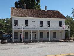 Buckland Station |
December 29, 1997 (#97001546) |
7 miles south of the junction of U.S. Route 50 and State Route 95 39°17′40″N 119°15′02″W |
Silver Springs | |
| 2 | East Walker River Petroglyph Site | July 24, 1980 (#80002468) |
Address Restricted |
Yerington | ||
| 3 | Fernley and Lassen Railway Depot | 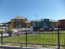 Fernley and Lassen Railway Depot |
June 1, 2005 (#05000513) |
675 E. Main St. 39°36′21″N 119°14′12″W |
Fernley | |
| 4 | Fernley Community Church | 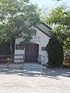 Fernley Community Church |
May 16, 2003 (#03000414) |
80 S. Center St. 39°36′24″N 119°15′05″W |
Fernley | |
| 5 | Fort Churchill | 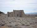 Fort Churchill |
October 15, 1966 (#66000456) |
U.S. Route 95 Alternate, 8 miles south of U.S. Route 50 39°17′33″N 119°16′14″W |
Silver Springs | |
| 6 | I.O.O.F. Building, Mason Valley | August 4, 1983 (#83001111) |
1 S. Main St. 38°59′02″N 119°10′11″W |
Yerington | ||
| 7 | Lyon County Courthouse | 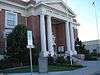 Lyon County Courthouse |
March 24, 1983 (#83001112) |
31 S. Main St. 38°59′11″N 119°09′46″W |
Yerington | |
| 8 | US Post Office-Yerington Main | 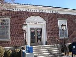 US Post Office-Yerington Main |
February 28, 1990 (#90000138) |
28 N. Main St. 38°59′17″N 119°09′42″W |
Yerington | |
| 9 | Virginia City Historic District | 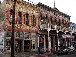 Virginia City Historic District |
October 15, 1966 (#66000458) |
Virginia City and its environs 39°15′35″N 119°35′19″W |
Virginia City | Extends into Storey County |
| 10 | Yerington Grammar School | August 16, 1984 (#84002075) |
112 N. California St. 38°59′20″N 119°09′37″W |
Yerington |
gollark: Why bother with the 5 char limit though?
gollark: Well, yeah. I doubt it actually checks on the backend what the length is.
gollark: This is madness. It's not safe to meddle with nature like this.
gollark: -9999 what?
gollark: Then we shall chaos-sort suggestions/requests into oblivion!
See also
| Wikimedia Commons has media related to National Register of Historic Places in Lyon County, Nevada. |
References
- The latitude and longitude information provided in this table was derived originally from the National Register Information System, which has been found to be fairly accurate for about 99% of listings. Some locations in this table may have been corrected to current GPS standards.
- "National Register of Historic Places: Weekly List Actions". National Park Service, United States Department of the Interior. Retrieved on August 14, 2020.
- Numbers represent an ordering by significant words. Various colorings, defined here, differentiate National Historic Landmarks and historic districts from other NRHP buildings, structures, sites or objects.
- The eight-digit number below each date is the number assigned to each location in the National Register Information System database, which can be viewed by clicking the number.
This article is issued from Wikipedia. The text is licensed under Creative Commons - Attribution - Sharealike. Additional terms may apply for the media files.