National Register of Historic Places listings in Lee County, Mississippi
This is a list of the National Register of Historic Places listings in Lee County, Mississippi.
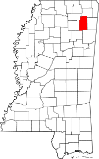
Location of Lee County in Mississippi
This is intended to be a complete list of the properties and districts on the National Register of Historic Places in Lee County, Mississippi, United States. Latitude and longitude coordinates are provided for many National Register properties and districts; these locations may be seen together in a map.[1]
There are 23 properties and districts listed on the National Register in the county.
- This National Park Service list is complete through NPS recent listings posted August 14, 2020.[2]
Current listings
| [3] | Name on the Register[4] | Image | Date listed[5] | Location | City or town | Description |
|---|---|---|---|---|---|---|
| 1 | Baldwyn Historic District[6] | July 20, 2011 (#11000471) |
Roughly along E. & W. Main Sts. & N. & S. 2nd Ave. 34°30′33″N 88°38′01″W |
Baldwyn | ||
| 2 | Brice's Cross Roads National Battlefield Site |  Brice's Cross Roads National Battlefield Site |
October 15, 1966 (#66000067) |
6 miles west of Baldwyn on Mississippi Highway 370 34°30′24″N 88°43′44″W |
Baldwyn | |
| 3 | Barlow Burrow House |  Barlow Burrow House |
March 1, 1984 (#84002251) |
157 N. 2nd St. 34°22′45″N 88°40′53″W |
Saltillo | |
| 4 | Carnation Milk Factory |  Carnation Milk Factory |
August 20, 2009 (#09000624) |
520 Carnation St. 34°15′14″N 88°42′34″W |
Tupelo | |
| 5 | R.C. Clark House | November 5, 2010 (#10000883) |
215 N. Church St. 34°15′31″N 88°42′31″W |
Tupelo | ||
| 6 | Downtown Tupelo Historic District | Downtown Tupelo Historic District |
June 2, 2014 (#14000276) |
Roughly bounded by Jefferson, Madison. N. Front, & Kansas City Southern RR. 34°15′27″N 88°42′25″W |
Tupelo | |
| 7 | First Methodist Church |  First Methodist Church |
March 15, 1990 (#90000348) |
412 W. Main St. 34°15′28″N 88°42′27″W |
Tupelo | |
| 8 | R.F. Goodlett House | April 3, 1992 (#92000162) |
219 Broadway 34°15′31″N 88°42′20″W |
Tupelo | ||
| 9 | Highland Circle Historic District | March 20, 2006 (#06000196) |
Highland Circle neighborhood, including parts of N. Madison St., Highland Circle, Oak Grove Rd., and W. Jackson St. 34°16′01″N 88°42′43″W |
Tupelo | ||
| 10 | Lee County Courthouse |  Lee County Courthouse |
April 3, 1992 (#92000161) |
Court St. between Spring and Broadway 34°15′31″N 88°42′17″W |
Tupelo | |
| 11 | Mill Village Historic District | April 3, 1992 (#92000159) |
Roughly bounded by the Illinois Central and St. Louis – San Francisco railroad tracks and Chestnut and Green Sts. 34°15′08″N 88°42′19″W |
Tupelo | ||
| 12 | Mutt-Thomason Site | August 31, 1978 (#78001611) |
Address Restricted |
Tupelo | ||
| 13 | North Broadway Historic District | .jpg) North Broadway Historic District |
October 31, 1985 (#85003438) |
300 block of N. Broadway St. 34°15′37″N 88°42′20″W |
Tupelo | |
| 14 | North Church Primary School |  North Church Primary School |
April 3, 1992 (#92000164) |
Southwestern corner of the junction of Church and Jackson Sts. 34°15′48″N 88°42′33″W |
Tupelo | |
| 15 | Old Superintendent's House, Tupelo Fish Hatchery |  Old Superintendent's House, Tupelo Fish Hatchery |
July 14, 1992 (#92000837) |
111 Elizabeth St. 34°14′55″N 88°42′07″W |
Tupelo | |
| 16 | Peoples Bank and Trust Company |  Peoples Bank and Trust Company |
August 24, 1978 (#78001610) |
211 Main St. 34°15′26″N 88°42′17″W |
Tupelo | |
| 17 | South Church Street Historic District | April 3, 1992 (#92000160) |
602-713 S. Church St. 34°15′05″N 88°42′30″W |
Tupelo | ||
| 18 | Spain House | 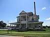 Spain House |
March 21, 2011 (#11000109) |
553 W. Main St. 34°15′26″N 88°42′37″W |
Tupelo | |
| 19 | F.L. Spight House | .jpg) F.L. Spight House |
April 3, 1992 (#92000163) |
363 N. Broadway 34°15′41″N 88°42′20″W |
Tupelo | |
| 20 | Stewart-Anderson House | .jpg) Stewart-Anderson House |
June 24, 1994 (#94000644) |
433 N. Church St. 34°15′45″N 88°42′34″W |
Tupelo | |
| 21 | Tombigbee State Park | March 25, 1999 (#99000382) |
Mississippi Highway 2 off U.S. Highway 78, southeast of Tupelo 34°13′51″N 88°37′24″W |
Tupelo | ||
| 22 | Tupelo Homesteads |  Tupelo Homesteads |
February 7, 1997 (#97000035) |
County Roads 657 and 665 and County Drive 647, south of its junction with the Natchez Trace Parkway 34°19′34″N 88°42′27″W |
Tupelo | |
| 23 | Tupelo National Battlefield |  Tupelo National Battlefield |
October 15, 1966 (#66000068) |
On Mississippi Highway 6 about 1 mile west of its junction with U.S. Route 45 34°15′19″N 88°44′14″W |
Tupelo |
gollark: Instead of generating political opinions using some standard methodology, you just map days of the year to political opinions.
gollark: It's obviously the product of a political opinion calendar.
gollark: But they also specified universal healthcare, basically just killing off people they don't like and capped profits on companies.
gollark: Oh, and their suggestion of "free 15Mbps internet connectivity" is underspecified and stupid. I would just have someone or other design a mandatorily-implemented-in-all-computers-with-communications-hardware self-organizing mesh network protocol.
gollark: Schools would be replaced with large warehouse-type spaces with computers, vaguely intelligent-looking adults and arbitrarily large quantities of children in them.
See also
| Wikimedia Commons has media related to National Register of Historic Places in Lee County, Mississippi. |
References
- The latitude and longitude information provided in this table was derived originally from the National Register Information System, which has been found to be fairly accurate for about 99% of listings. Some locations in this table may have been corrected to current GPS standards.
- "National Register of Historic Places: Weekly List Actions". National Park Service, United States Department of the Interior. Retrieved on August 14, 2020.
- Numbers represent an ordering by significant words. Various colorings, defined here, differentiate National Historic Landmarks and historic districts from other NRHP buildings, structures, sites or objects.
- "National Register Information System". National Register of Historic Places. National Park Service. March 13, 2009.
- The eight-digit number below each date is the number assigned to each location in the National Register Information System database, which can be viewed by clicking the number.
- "Weekly list of actions taken on properties: 7/18/11 through 7/22/11". National Park Service. July 29, 2011. Retrieved September 14, 2012.
| Topics | |
|---|---|
| Lists by state |
|
| Lists by insular areas | |
| Lists by associated state | |
| Other areas | |
| Related | |
| |
Municipalities and communities of Lee County, Mississippi, United States | ||
|---|---|---|
| Cities | Map of Mississippi highlighting Lee County | |
| Towns | ||
| CDP | ||
Unincorporated communities | ||
| Ghost town | ||
| Footnotes | ‡This populated place also has portions in an adjacent county or counties | |
This article is issued from Wikipedia. The text is licensed under Creative Commons - Attribution - Sharealike. Additional terms may apply for the media files.