National Register of Historic Places listings in Hyde County, South Dakota
This is a list of the National Register of Historic Places listings in Hyde County, South Dakota.
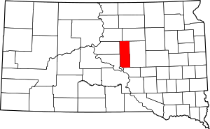
Location of Hyde County in South Dakota
This is intended to be a complete list of the properties on the National Register of Historic Places in Hyde County, South Dakota, United States. The locations of National Register properties for which the latitude and longitude coordinates are included below, may be seen in a map.[1]
There are 4 properties listed on the National Register in the county.
- This National Park Service list is complete through NPS recent listings posted August 14, 2020.[2]
Current listings
| [3] | Name on the Register[4] | Image | Date listed[5] | Location | City or town | Description |
|---|---|---|---|---|---|---|
| 1 | Archeological Site No. 39HE331 |  Archeological Site No. 39HE331 |
August 6, 1993 (#93000793) |
Address Restricted |
Holabird | |
| 2 | Augustus and Augusta Gerhart House | September 4, 1997 (#97001106) |
321 Iowa St. 44°31′03″N 99°26′30″W |
Highmore | ||
| 3 | Hyde County Courthouse | March 30, 1978 (#78002558) |
412 Commercial St., SE. 44°30′59″N 99°26′21″W |
Highmore | ||
| 4 | Hyde County Memorial Auditorium | August 24, 2018 (#100002809) |
200 2nd St SW 44°31′09″N 99°26′34″W |
Highmore |
Former listings
| [3] | Name on the Register | Image | Date listed | Date removed | Location | City or town | Summary |
|---|---|---|---|---|---|---|---|
| 1 | Old Hyde County Courthouse | April 19, 1978 (#78002559) | August 21, 1997 | 110 Commercial St., SE. |
Highmore |
gollark: Wow, it hit the 15:1 V/UV ratio.
gollark: Yes, because I'm using my maaaagic AR tool on it.
gollark: Also, I can AR it, and since it's ER-timed so can anyone using the NDER.
gollark: Just use moar hatcheries.
gollark: I do also have a CB aeon around now.
See also
References
- The latitude and longitude information provided in this table was derived originally from the National Register Information System, which has been found to be fairly accurate for about 99% of listings. Some locations in this table may have been corrected to current GPS standards.
- "National Register of Historic Places: Weekly List Actions". National Park Service, United States Department of the Interior. Retrieved on August 14, 2020.
- Numbers represent an ordering by significant words. Various colorings, defined here, differentiate National Historic Landmarks and historic districts from other NRHP buildings, structures, sites or objects.
- "National Register Information System". National Register of Historic Places. National Park Service. April 24, 2008.
- The eight-digit number below each date is the number assigned to each location in the National Register Information System database, which can be viewed by clicking the number.
| Topics | |
|---|---|
| Lists by state |
|
| Lists by insular areas | |
| Lists by associated state | |
| Other areas | |
| Related | |
| |
Municipalities and communities of Hyde County, South Dakota, United States | ||
|---|---|---|
| City | | |
| Unincorporated communities | ||
| Indian reservation | ||
| Footnotes | ‡This populated place also has portions in an adjacent county or counties | |
This article is issued from Wikipedia. The text is licensed under Creative Commons - Attribution - Sharealike. Additional terms may apply for the media files.