National Register of Historic Places listings in Hall County, Nebraska
This is a list of the National Register of Historic Places listings in Hall County, Nebraska.
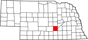
Location of Hall County in Nebraska
This is intended to be a complete list of the properties and districts on the National Register of Historic Places in Hall County, Nebraska, United States. The locations of National Register properties and districts for which the latitude and longitude coordinates are included below, may be seen in a map.[1]
There are 27 properties and districts listed on the National Register in the county.
- This National Park Service list is complete through NPS recent listings posted August 14, 2020.[2]
Current listings
| [3] | Name on the Register | Image | Date listed[4] | Location | City or town | Description |
|---|---|---|---|---|---|---|
| 1 | 4th Street Commercial Historic District | July 1, 2019 (#100004141) |
Roughly bounded by alley S of 5th St., N. Sycamore St., Union Pacific RR Tracks, and N. Cedar St. 40°55′39″N 98°20′38″W |
Grand Island | ||
| 2 | H.J. Bartenbach House | 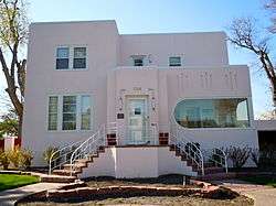 H.J. Bartenbach House |
December 8, 1986 (#86003385) |
720 W. Division 40°55′13″N 98°20′43″W |
Grand Island | |
| 3 | Burlington Railroad Depot | Burlington Railroad Depot |
December 2, 2014 (#14001013) |
603 N. Plum St. 40°55′57″N 98°20′16″W |
Grand Island | |
| 4 | Cathedral of the Nativity of the Blessed Virgin Mary | _cathedral_interior_1.JPG) Cathedral of the Nativity of the Blessed Virgin Mary |
July 15, 1982 (#82003189) |
204 S. Cedar St. 40°55′16″N 98°20′32″W |
Grand Island | |
| 5 | Evangelische Lutherische Dreienigkeit Kirche | 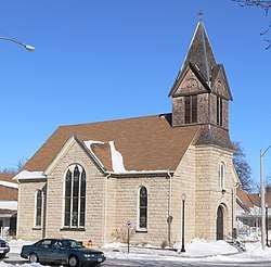 Evangelische Lutherische Dreienigkeit Kirche |
December 1, 1986 (#86003378) |
512 E. 2nd St. 40°55′38″N 98°20′04″W |
Grand Island | |
| 6 | Heinrich Giese House | 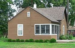 Heinrich Giese House |
July 26, 2006 (#06000641) |
2226 S. Blaine 40°53′59″N 98°21′55″W |
Grand Island | |
| 7 | Glade-Donald House | 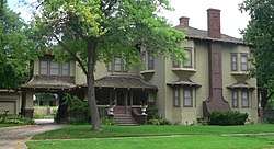 Glade-Donald House |
September 12, 1985 (#85002140) |
1004 W. Division 40°55′09″N 98°20′53″W |
Grand Island | |
| 8 | Gloe Brothers Service Station |  Gloe Brothers Service Station |
July 5, 2000 (#00000768) |
609 E. 11th St. 40°49′20″N 98°35′38″W |
Wood River | |
| 9 | Grand Island Carnegie Library | 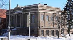 Grand Island Carnegie Library |
May 2, 1975 (#75001094) |
321 W. 2nd St. 40°55′25″N 98°20′30″W |
Grand Island | |
| 10 | Grand Island FCC Monitoring Station | Grand Island FCC Monitoring Station |
January 16, 1973 (#73001064) |
609 N. Monitor Road[5] 40°55′33″N 98°26′08″W |
Grand Island | |
| 11 | Grand Island Historic District | December 13, 2017 (#100001800) |
Multiple 40°55′32″N 98°20′28″W |
Grand Island | ||
| 12 | Grand Island Senior High School | 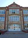 Grand Island Senior High School |
November 22, 1999 (#99001390) |
504 Elm St. 40°55′44″N 98°21′01″W |
Grand Island | |
| 13 | Grand Island United States Post Office and Courthouse | 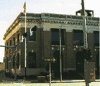 Grand Island United States Post Office and Courthouse |
February 14, 2006 (#06000044) |
203 W. 2nd St. 40°55′27″N 98°20′25″W |
Grand Island | |
| 14 | Grand Island VA Hospital | July 13, 2018 (#100002664) |
2201 N Broadwell Ave. 40°56′35″N 98°21′25″W |
Grand Island | ||
| 15 | Hall County Courthouse | 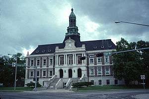 Hall County Courthouse |
September 15, 1977 (#77000831) |
1st and Locust 40°55′25″N 98°20′20″W |
Grand Island | |
| 16 | Hamilton-Donald House | 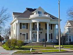 Hamilton-Donald House |
March 13, 1986 (#86000390) |
820 W. 2nd St. 40°55′18″N 98°20′52″W |
Grand Island | |
| 17 | Andrew M. Hargis House | 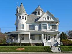 Andrew M. Hargis House |
June 9, 1978 (#78001700) |
1109 W. 2nd St. 40°55′13″N 98°21′00″W |
Grand Island | |
| 18 | The Hotel Yancey | 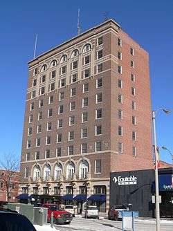 The Hotel Yancey |
December 13, 1984 (#84000504) |
123 N. Locust St. 40°55′28″N 98°20′23″W |
Grand Island | |
| 19 | Lee Huff Apartment Complex | 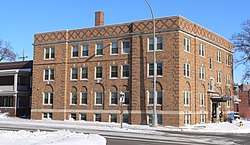 Lee Huff Apartment Complex |
July 1, 1994 (#94000652) |
213-215½ S. Walnut St., 324 W. Koenig St., and 316-318½ W. Koenig St. 40°55′16″N 98°20′25″W |
Grand Island | |
| 20 | Liederkranz | 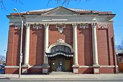 Liederkranz |
November 30, 1978 (#78001701) |
401 W. 1st St. 40°55′21″N 98°20′30″W |
Grand Island | |
| 21 | Lincoln Highway-Grand Island Seedling Mile |  Lincoln Highway-Grand Island Seedling Mile |
April 24, 2013 (#13000198) |
Seedling Mile Rd. 40°55′51″N 98°19′27″W |
Grand Island | |
| 22 | Nine Bridges Bridge | Nine Bridges Bridge |
June 29, 1992 (#92000716) |
Private road over the Middle Channel of the Platte River, 3.9 miles north of Doniphan 40°49′40″N 98°22′47″W |
Doniphan | |
| 23 | Oscar Roeser House | 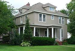 Oscar Roeser House |
June 25, 1982 (#82003190) |
721 W. Koenig St. 40°55′09″N 98°20′40″W |
Grand Island | |
| 24 | Shady Bend Gas Station, Grocery, and Diner | _4.jpg) Shady Bend Gas Station, Grocery, and Diner |
July 2, 2008 (#08000601) |
3609 E. U.S. Route 30 40°56′19″N 98°18′03″W |
Grand Island | |
| 25 | Stolley Homestead Site | 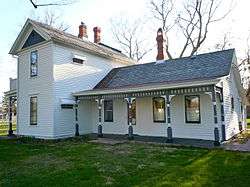 Stolley Homestead Site |
March 16, 1972 (#72001584) |
Stolley Park 40°54′02″N 98°21′33″W |
Grand Island | |
| 26 | Stuhr Museum of the Prairie Pioneer | 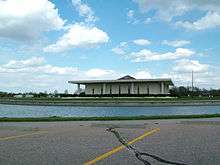 Stuhr Museum of the Prairie Pioneer |
June 29, 2015 (#15000396) |
3133 US 34 40°53′02″N 98°22′24″W |
Grand Island | |
| 27 | Townsley-Murdock Immigrant Trail Site | 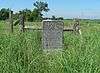 Townsley-Murdock Immigrant Trail Site |
March 5, 1998 (#98000194) |
Approximately 1.5 miles south of Alda 40°50′42″N 98°28′27″W |
Alda |
gollark: I mean the generalized thing where once you are in a situation you probably can't escape from you *may* just trick yourself into thinking the situation is cool and good.
gollark: That sounds like cognitive dissonance/weird generalized Stockholm syndrome or something.
gollark: Plus, people break up lots so this is obviously not true.
gollark: Well, you shouldn't trust them entirely, that's ridiculous.
gollark: https://www.smbc-comics.com/comic/the-talk-3
See also
| Wikimedia Commons has media related to National Register of Historic Places in Hall County, Nebraska. |
References
- The latitude and longitude information provided in this table was derived originally from the National Register Information System, which has been found to be fairly accurate for about 99% of listings. Some locations in this table may have been corrected to current GPS standards.
- "National Register of Historic Places: Weekly List Actions". National Park Service, United States Department of the Interior. Retrieved on August 14, 2020.
- Numbers represent an ordering by significant words. Various colorings, defined here, differentiate National Historic Landmarks and historic districts from other NRHP buildings, structures, sites or objects.
- The eight-digit number below each date is the number assigned to each location in the National Register Information System database, which can be viewed by clicking the number.
- See photo
| Topics | |
|---|---|
| Lists by state |
|
| Lists by insular areas | |
| Lists by associated state | |
| Other areas | |
| Related | |
| |
Municipalities and communities of Hall County, Nebraska, United States | ||
|---|---|---|
| Cities | Map of Nebraska highlighting Hall County | |
| Villages | ||
| Townships |
| |
| Unincorporated communities | ||
| Footnotes | ‡This populated place also has portions in an adjacent county or counties | |
This article is issued from Wikipedia. The text is licensed under Creative Commons - Attribution - Sharealike. Additional terms may apply for the media files.