National Register of Historic Places listings in Grant County, South Dakota
This is a list of the National Register of Historic Places listings in Grant County, South Dakota.
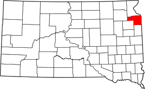
Location of Grant County in South Dakota
This is intended to be a complete list of the properties and districts on the National Register of Historic Places in Grant County, South Dakota, United States. The locations of National Register properties and districts for which the latitude and longitude coordinates are included below, may be seen in a map.[1]
There are 15 properties and districts listed on the National Register in the county.
- This National Park Service list is complete through NPS recent listings posted August 14, 2020.[2]
Current listings
| [3] | Name on the Register[4] | Image | Date listed[5] | Location | City or town | Description |
|---|---|---|---|---|---|---|
| 1 | Big Stone City Hall | 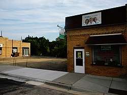 Big Stone City Hall |
July 28, 2004 (#04000764) |
469 Main 45°17′37″N 96°27′48″W |
Big Stone City | |
| 2 | Brown Earth Presbyterian Church | 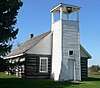 Brown Earth Presbyterian Church |
August 29, 1984 (#84003288) |
Northeast of Stockholm 45°07′20″N 96°46′20″W |
Stockholm | |
| 3 | First Congregational Church of Milbank | 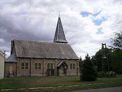 First Congregational Church of Milbank |
April 19, 1978 (#78002553) |
E. 3rd Ave. 45°13′31″N 96°37′39″W |
Milbank | |
| 4 | First National Bank of Milbank | 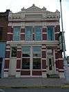 First National Bank of Milbank |
April 19, 1978 (#78002554) |
225 S. Main St. 45°13′13″N 96°38′10″W |
Milbank | |
| 5 | First State Bank Building | 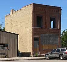 First State Bank Building |
February 26, 1987 (#87000221) |
2nd Ave and 4th St[6] 45°00′59″N 96°34′17″W |
Revillo | |
| 6 | Herman Freiwald Barn[7] |  Herman Freiwald Barn[9] |
February 19, 2008 (#08000045) |
48603 148th St. 45°14′20″N 96°28′23″W[10]) |
Big Stone City | |
| 7 | James A. and Ida Bell Gold House | 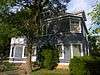 James A. and Ida Bell Gold House |
February 19, 2008 (#08000046) |
202 2nd Ave. 45°17′51″N 96°27′52″W |
Big Stone City | |
| 8 | Grant County Courthouse | 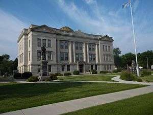 Grant County Courthouse |
February 10, 1993 (#92001858) |
Junction of Park Ave. and Main St. 45°13′03″N 96°38′08″W |
Milbank | |
| 9 | Hollands Grist Mill | 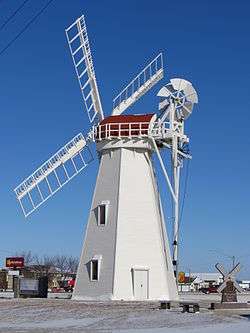 Hollands Grist Mill |
February 24, 1981 (#81000573) |
U.S. Route 12 45°13′21″N 96°37′07″W |
Milbank | |
| 10 | Emil and Hannah Johnson House | 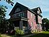 Emil and Hannah Johnson House |
February 19, 2008 (#08000047) |
117 Diggs Ave. 45°13′39″N 96°38′20″W |
Milbank | |
| 11 | George and Mary Koch Farm | 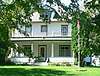 George and Mary Koch Farm |
February 19, 2008 (#08000048) |
14849 474th Ave. 45°13′48″N 96°43′18″W |
Twin Brooks | |
| 12 | Lebanon Lutheran Church | _from_SW_2.jpg) Lebanon Lutheran Church |
September 15, 1977 (#77001244) |
146 St and 452 Ave[11] 45°16′02″N 97°09′52″W |
Summit | |
| 13 | Milbank Carnegie Library |  Milbank Carnegie Library |
November 21, 1978 (#78002555) |
S. 3rd Ave. 45°13′31″N 96°38′17″W |
Milbank | |
| 14 | Ole Nelson Barn | _from_NW_1.jpg) Ole Nelson Barn |
February 19, 2008 (#08000049) |
14674 454th Ave. 45°15′30″N 97°07′20″W |
Summit | |
| 15 | Swedish Lutheran Church of Strandburg | 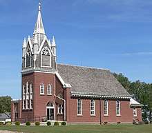 Swedish Lutheran Church of Strandburg |
February 17, 1978 (#78002556) |
162 St and 472 Ave[12] 45°02′27″N 96°45′38″W |
Strandburg |
gollark: It's designed for random access.
gollark: https://www.kiwix.org/en/
gollark: It's not designed as a way to pack Wikipedia into less space, they have database dumps already.
gollark: The software is designed to allow people to quickly look up a specific page in it.
gollark: No, actually.
See also
| Wikimedia Commons has media related to National Register of Historic Places in Grant County, South Dakota. |
References
- The latitude and longitude information provided in this table was derived originally from the National Register Information System, which has been found to be fairly accurate for about 99% of listings. Some locations in this table may have been corrected to current GPS standards.
- "National Register of Historic Places: Weekly List Actions". National Park Service, United States Department of the Interior. Retrieved on August 14, 2020.
- Numbers represent an ordering by significant words. Various colorings, defined here, differentiate National Historic Landmarks and historic districts from other NRHP buildings, structures, sites or objects.
- "National Register Information System". National Register of Historic Places. National Park Service. April 24, 2008.
- The eight-digit number below each date is the number assigned to each location in the National Register Information System database, which can be viewed by clicking the number.
- See 2017 photo, including street sign
- Listed on NRHP as "Herman Friewald Barn"; but name is spelled "Freiwald" throughout nominating form
- Listed on NRHP as "Herman Friewald Barn"; but name is spelled "Freiwald" throughout nominating form
- Listed on NRHP as "Herman Friewald Barn"; but name is spelled "Freiwald" throughout nominating form
- Listed on NRHP as "Herman Friewald Barn"; but name is spelled "Freiwald" throughout nominating form
- See 2017 photo, including street sign
- See 2017 photo, including street sign
| Topics | |
|---|---|
| Lists by state |
|
| Lists by insular areas | |
| Lists by associated state | |
| Other areas | |
| Related | |
| |
Municipalities and communities of Grant County, South Dakota, United States | ||
|---|---|---|
| Cities | | |
| Towns | ||
| Townships | ||
| Unincorporated community | ||
| Indian reservation | ||
| Footnotes | ‡This populated place also has portions in an adjacent county or counties | |
This article is issued from Wikipedia. The text is licensed under Creative Commons - Attribution - Sharealike. Additional terms may apply for the media files.