National Register of Historic Places listings in Elmore County, Idaho
This is a list of the National Register of Historic Places listings in Elmore County, Idaho.

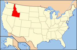
Location of Elmore County in Idaho
This is intended to be a complete list of the properties and districts on the National Register of Historic Places in Elmore County, Idaho, United States. Latitude and longitude coordinates are provided for many National Register properties and districts; these locations may be seen together in a map.[1]
There are 23 properties and districts listed on the National Register in the county. More may be added; properties and districts nationwide are added to the Register weekly.[2]
- This National Park Service list is complete through NPS recent listings posted August 14, 2020.[3]
Current listings
| [4] | Name on the Register[5] | Image | Date listed[6] | Location | City or town | Description |
|---|---|---|---|---|---|---|
| 1 | F. P. Ake Building | 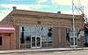 F. P. Ake Building |
November 17, 1982 (#82000337) |
160–172 N. Main St. 43°07′52″N 115°41′40″W |
Mountain Home | |
| 2 | Amstutz Apartments[7] | 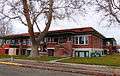 Amstutz Apartments[9] |
September 23, 1982 (#82002511) |
320 S. Ada St. 42°57′01″N 115°17′59″W[10]) |
Glenns Ferry | |
| 3 | Pedro Anchustegui Pelota Court | 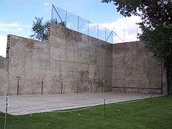 Pedro Anchustegui Pelota Court |
January 30, 1978 (#78001060) |
W. 2nd North St. 43°07′49″N 115°41′50″W |
Mountain Home | |
| 4 | Atlanta Dam and Power Plant | October 5, 1977 (#77000459) |
West of Atlanta on the Boise River 43°48′12″N 115°09′48″W |
Atlanta | ||
| 5 | Atlanta Historic District | April 6, 1978 (#78001059) |
Quartz Creek, Pine and Main Sts. 43°48′07″N 115°07′47″W |
Atlanta | ||
| 6 | Atlanta Ranger Station Historic District |  Atlanta Ranger Station Historic District |
January 23, 2003 (#02001726) |
Boise National Forest 43°48′18″N 115°07′49″W |
Atlanta | |
| 7 | Elmore County Courthouse |  Elmore County Courthouse |
September 22, 1987 (#87001584) |
150 S. 4th East 43°07′54″N 115°41′25″W |
Mountain Home | |
| 8 | Featherville School[11] | December 2, 2019 (#100004709) |
4348 N. Pine-Featherville Rd. 43°36′34″N 115°15′34″W[12]) |
Featherville | ||
| 9 | Glenns Ferry School |  Glenns Ferry School |
September 7, 1984 (#84001122) |
161 W. Cleveland Ave. 42°57′01″N 115°18′02″W |
Glenns Ferry | Now Glenns Ferry Historical Museum |
| 10 | Gorby Opera Theater | 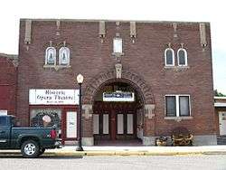 Gorby Opera Theater |
November 17, 1982 (#82000339) |
128 E. Idaho Ave. 42°57′15″N 115°17′55″W |
Glenns Ferry | |
| 11 | Guffey Butte – Black Butte Archeological District |  Guffey Butte – Black Butte Archeological District |
October 10, 1978 (#78001038) |
Along approximately 34 miles (55 km) of the Snake River in Canyon, Ada, Owyhee, and Elmore counties[13] 43°05′11″N 116°11′29″W |
Grand View | |
| 12 | KwikCurb Diner |  KwikCurb Diner |
July 26, 2010 (#10000502) |
850 S. 3rd West Street 43°07′22″N 115°41′24″W |
Mountain Home | |
| 13 | Father Lobell House | 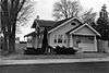 Father Lobell House |
November 17, 1982 (#82000338) |
125 N. 4th East St. 43°07′56″N 115°41′29″W |
Mountain Home | Building no longer exists. |
| 14 | J. S. McGinnis Building |  J. S. McGinnis Building |
November 17, 1982 (#82000340) |
71–83 N. Commercial St. 42°57′15″N 115°18′02″W |
Glenns Ferry | |
| 15 | Mountain Home Baptist Church |  Mountain Home Baptist Church |
November 17, 1982 (#82000341) |
265 N. 4th East St. 43°08′00″N 115°41′33″W |
Mountain Home | Building no longer exists. |
| 16 | Mountain Home Carnegie Library | 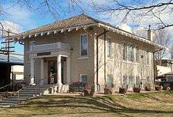 Mountain Home Carnegie Library |
July 24, 1978 (#78001061) |
180 S. 3rd East 43°07′51″N 115°41′28″W |
Mountain Home | |
| 17 | Mountain Home High School |  Mountain Home High School |
August 8, 1991 (#91000988) |
550 E. Jackson St. 43°08′00″N 115°41′18″W |
Mountain Home | |
| 18 | Mountain Home Hotel | 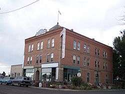 Mountain Home Hotel |
October 29, 1982 (#82000385) |
195 N. 2nd West St. 43°07′50″N 115°41′47″W |
Mountain Home | |
| 19 | O'Neill Brothers Building | 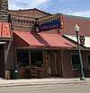 O'Neill Brothers Building |
November 17, 1982 (#82000342) |
36 E. Idaho Ave. 42°57′14″N 115°17′59″W |
Glenns Ferry | |
| 20 | Our Lady of Limerick Catholic Church | 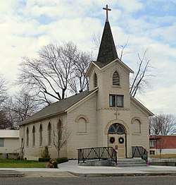 Our Lady of Limerick Catholic Church |
November 17, 1982 (#82000343) |
113 W. Arthur Ave. 42°57′00″N 115°17′56″W |
Glenns Ferry | |
| 21 | St. James Episcopal Church |  St. James Episcopal Church |
October 5, 1977 (#77000460) |
305 N. 3rd East St. 43°08′00″N 115°41′38″W |
Mountain Home | |
| 22 | South Boise Historic Mining District | 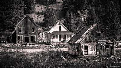 South Boise Historic Mining District |
December 30, 1975 (#75000629) |
In the Boise and Sawtooth National Forests 43°41′31″N 115°15′54″W |
Rocky Bar | 10 square mile gold mining district including the ghost town of Rocky Bar, Idaho |
| 23 | Turner Hotel | 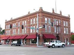 Turner Hotel |
September 7, 1984 (#84001124) |
140-170 E. Jackson St. 43°07′52″N 115°41′36″W |
Mountain Home |
gollark: Troubling.
gollark: Everyone else just seems to assume it's a pizza because it's circular and yellow/reddish.
gollark: FINALLY someone doesn't assume it's a pizza.
gollark: Greetings, mortals.
gollark: I saw.
See also
| Wikimedia Commons has media related to National Register of Historic Places in Elmore County, Idaho. |
References
- The latitude and longitude information provided in this table was derived originally from the National Register Information System, which has been found to be fairly accurate for about 99% of listings. Some locations in this table may have been corrected to current GPS standards.
- "National Register of Historic Places: Weekly List Actions". National Park Service. Retrieved March 29, 2009.
- "National Register of Historic Places: Weekly List Actions". National Park Service, United States Department of the Interior. Retrieved on August 14, 2020.
- Numbers represent an ordering by significant words. Various colorings, defined here, differentiate National Historic Landmarks and historic districts from other NRHP buildings, structures, sites or objects.
- "National Register Information System". National Register of Historic Places. National Park Service. April 24, 2008.
- The eight-digit number below each date is the number assigned to each location in the National Register Information System database, which can be viewed by clicking the number.
- "National Register of Historic Places Registration Form: Amstutz Apartments" (PDF). United States Department of the Interior; National Park Service. Retrieved December 28, 2019.
- "National Register of Historic Places Registration Form: Amstutz Apartments" (PDF). United States Department of the Interior; National Park Service. Retrieved December 28, 2019.
- "National Register of Historic Places Registration Form: Amstutz Apartments" (PDF). United States Department of the Interior; National Park Service. Retrieved December 28, 2019.
- "National Register of Historic Places Registration Form: Amstutz Apartments" (PDF). United States Department of the Interior; National Park Service. Retrieved December 28, 2019.
- "National Register of Historic Places Registration Form: Featherville School" (PDF). United States Department of the Interior; National Park Service. Retrieved December 26, 2019.
- "National Register of Historic Places Registration Form: Featherville School" (PDF). United States Department of the Interior; National Park Service. Retrieved December 26, 2019.
- Map #8 - Guffey Butte / Black Butte Historical District (PDF) (Map). Bureau of Land Management. January 28, 2011. Retrieved March 14, 2015. Coordinates mark the approximate midpoint of the portion of the historic district in Elmore County.
| Topics | |
|---|---|
| Lists by state |
|
| Lists by insular areas | |
| Lists by associated state | |
| Other areas | |
| Related | |
| |
Municipalities and communities of Elmore County, Idaho, United States | ||
|---|---|---|
| Cities | Map of Idaho highlighting Elmore County | |
| CDP | ||
| Unincorporated communities | ||
This article is issued from Wikipedia. The text is licensed under Creative Commons - Attribution - Sharealike. Additional terms may apply for the media files.