National Register of Historic Places listings in Edmunds County, South Dakota
This is a list of the National Register of Historic Places listings in Edmunds County, South Dakota.
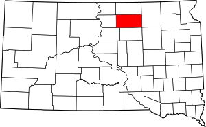
Location of Edmunds County in South Dakota
This is intended to be a complete list of the properties on the National Register of Historic Places in Edmunds County, South Dakota, United States. The locations of National Register properties and districts for which the latitude and longitude coordinates are included below, may be seen in a map.[1]
There are 11 properties listed on the National Register in the county. Another 2 properties were once listed but have been removed.
- This National Park Service list is complete through NPS recent listings posted August 14, 2020.[2]
Current listings
| [3] | Name on the Register[4] | Image | Date listed[5] | Location | City or town | Description |
|---|---|---|---|---|---|---|
| 1 | Bank of Bowdle | 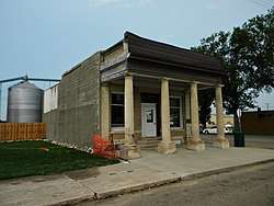 Bank of Bowdle |
January 31, 1985 (#85000183) |
3026 Main Street 45°27′19″N 99°39′13″W |
Bowdle | |
| 2 | Marcus P. Beebe Library | November 16, 1977 (#77001243) |
Main Street and Second Avenue 45°26′15″N 99°01′31″W |
Ipswich | ||
| 3 | Marcus Beebe House | December 12, 1976 (#76001733) |
4th Street and 5th Avenue 45°26′56″N 99°01′45″W |
Ipswich | ||
| 4 | Bierman Barn | October 7, 1998 (#96001230) |
14315 372nd Avenue 45°16′16″N 98°45′19″W |
Mansfield | ||
| 5 | Edmunds County Courthouse | August 16, 2000 (#00000997) |
Second Avenue between Second and Third Streets 45°26′45″N 99°01′32″W |
Ipswich | ||
| 6 | Ipswich Baptist Church | January 30, 1978 (#78002550) |
Main Street and Third Avenue 45°26′41″N 99°01′32″W |
Ipswich | ||
| 7 | Ipswich Masonic Temple | June 30, 2020 (#100005320) |
318 2nd Ave. 45°26′43″N 99°01′39″W |
Ipswich | ||
| 8 | Ipswich State Bank | 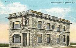 Ipswich State Bank |
May 22, 1978 (#78002551) |
First Avenue and Main Street 45°26′12″N 99°01′30″W |
Ipswich | |
| 9 | Parmley Land Office | March 26, 1979 (#79002402) |
119 Main Street 45°26′42″N 99°01′40″W |
Ipswich | ||
| 10 | J.W. Parmley House | June 4, 1980 (#80003720) |
4th Street and 4th Avenue 45°26′38″N 99°01′48″W |
Ipswich | ||
| 11 | John Strouckel House | November 28, 1984 (#84001268) |
Northeastern corner of the eastern half of Section 33, T122N, R72W, west of Loyalton Address Restricted |
Loyalton |
Former listings
| [3] | Name on the Register | Image | Date listed | Date removed | Location | City or town | Summary |
|---|---|---|---|---|---|---|---|
| 1 | John Eisenbeis House | August 13, 1984 (#84003283) | October 30, 2017 | West of Highway 47 in the southern half of the southwestern quadrant of Section 17, T124N, R73W[6] |
Bowdle | ||
| 2 | Roscoe Community Hall | August 1, 1984[7] (#84003284) | August 16, 2013 | 202 Mitchell Street 45°27′00″N 99°20′15″W |
Roscoe | Demolished;[8] |
gollark: I disagree with use of Go on ethical grounds.
gollark: Shame it doesn't actually work because I can't click any buttons.
gollark: It appears that Forge/Minecraft is now highly optimized, and able to use all my available cores to load things.
gollark: Britain is* in the EU and also** in the Eurozone, yes.
gollark: This is useful*.
See also
| Wikimedia Commons has media related to National Register of Historic Places in Edmunds County, South Dakota. |
References
- The latitude and longitude information provided in this table was derived originally from the National Register Information System, which has been found to be fairly accurate for about 99% of listings. Some locations in this table may have been corrected to current GPS standards.
- "National Register of Historic Places: Weekly List Actions". National Park Service, United States Department of the Interior. Retrieved on August 14, 2020.
- Numbers represent an ordering by significant words. Various colorings, defined here, differentiate National Historic Landmarks and historic districts from other NRHP buildings, structures, sites or objects.
- "National Register Information System". National Register of Historic Places. National Park Service. April 24, 2008.
- The eight-digit number below each date is the number assigned to each location in the National Register Information System database, which can be viewed by clicking the number.
- Location derived from its NRHP nomination form; the NRIS lists it as "Address Restricted"
- "National Register of Historic Places Program: Weekly List". National Park Service. Retrieved August 20, 2013.
- "National Register of Historic Places Evaluation/Return Sheet" (PDF). National Park Service. Retrieved August 20, 2013.
| Topics | |
|---|---|
| Lists by state |
|
| Lists by insular areas | |
| Lists by associated state | |
| Other areas | |
| Related | |
| |
Municipalities and communities of Edmunds County, South Dakota, United States | ||
|---|---|---|
| Cities | | |
| Unincorporated communities | ||
| Townships |
| |
This article is issued from Wikipedia. The text is licensed under Creative Commons - Attribution - Sharealike. Additional terms may apply for the media files.