National Register of Historic Places listings in Clay County, South Dakota
This is a list of the National Register of Historic Places listings in Clay County, South Dakota.
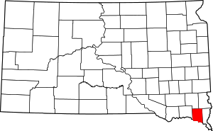
Location of Clay County in South Dakota
This is intended to be a complete list of the properties and districts on the National Register of Historic Places in Clay County, South Dakota, United States. The locations of National Register properties and districts for which the latitude and longitude coordinates are included below, may be seen in a map.[1]
There are 39 properties and districts listed on the National Register in the county. Another 2 properties were once listed but have since been removed.
- This National Park Service list is complete through NPS recent listings posted August 14, 2020.[2]
Current listings
| [3] | Name on the Register[4] | Image | Date listed[5] | Location | City or town | Description |
|---|---|---|---|---|---|---|
| 1 | Anderson Homestead | March 30, 1978 (#78002543) |
East of Hub City 42°57′45″N 96°48′23″W |
Hub City | ||
| 2 | William Andre House | _from_SW_2.JPG) William Andre House |
October 31, 2002 (#02001284) |
31256 452nd Ave. 42°51′29″N 97°09′35″W |
Gayville | |
| 3 | Austin-Whittemore House | 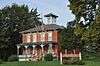 Austin-Whittemore House |
October 18, 1972 (#72001225) |
15 Austin Ave. 42°46′44″N 96°56′07″W |
Vermillion | Now a local history museum. |
| 4 | Bluff Historic District | June 23, 2016 (#16000415) |
Oak Pl. and Court, Kidder, Church, and Bloomingdale Sts. 42°46′38″N 96°55′54″W |
Vermillion | ||
| 5 | Bluff View Cemetery Chapel | 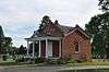 Bluff View Cemetery Chapel |
May 31, 2006 (#06000458) |
0.2 miles south of junction of Crawford Rd. and Pinehurst Dr. 42°46′25″N 96°54′20″W |
Vermillion | |
| 6 | Building at 125 Ohio St. | 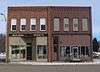 Building at 125 Ohio St. |
February 14, 2002 (#02000021) |
125 Ohio St. 43°00′31″N 97°06′25″W |
Wakonda | |
| 7 | Burbank School No. 10 | 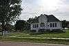 Burbank School No. 10 |
July 5, 1996 (#96000740) |
White St., 2 blocks north of the former Chicago, Milwaukee, St. Paul and Pacific railroad tracks. 42°44′53″N 96°49′41″W |
Burbank | |
| 8 | Clay County Courthouse | 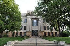 Clay County Courthouse |
August 18, 1983 (#83003005) |
211 W. Main St. 42°46′47″N 96°56′08″W |
Vermillion | |
| 9 | Colton House | 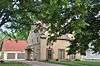 Colton House |
November 19, 2007 (#07001210) |
402 S. University St. 42°46′37″N 96°55′26″W |
Vermillion | |
| 10 | Downtown Vermillion Historic District | 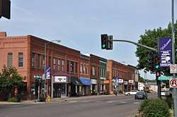 Downtown Vermillion Historic District |
March 7, 2003 (#02001288) |
Main St., roughly bounded by Market and Dakota Sts. 42°46′45″N 96°55′52″W |
Vermillion | |
| 11 | First Baptist Church of Vermillion | 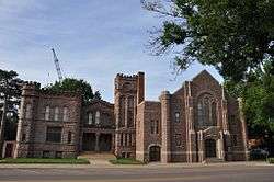 First Baptist Church of Vermillion |
March 5, 1982 (#82003921) |
101 E. Main St. 42°46′44″N 96°55′49″W |
Vermillion | |
| 12 | First Methodist Episcopal Church | 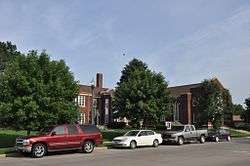 First Methodist Episcopal Church |
January 28, 2004 (#03001522) |
14-16 North Dakota St. 42°46′46″N 96°55′46″W |
Vermillion | |
| 13 | First National Bank Building of Vermillion | 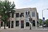 First National Bank Building of Vermillion |
February 13, 1986 (#86000244) |
1 E. Main St. 42°46′45″N 96°55′54″W |
Vermillion | |
| 14 | Forest Avenue Historic District |  Forest Avenue Historic District |
October 18, 1979 (#79002400) |
Forest Ave. and Lewis St. Boundary clarification (listed March 6, 2012, refnum 12000086): 15-322 Forest Ave., 205-221 Lewis St. 42°46′36″N 96°55′43″W |
Vermillion | |
| 15 | Garfield Township Hall | 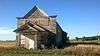 Garfield Township Hall |
January 28, 2004 (#03001523) |
16667 306th St. 42°57′08″N 96°51′50″W |
Beresford | |
| 16 | Gunderson House | 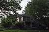 Gunderson House |
February 9, 2001 (#01000092) |
24 S. Harvard 42°46′38″N 96°55′39″W |
Vermillion | |
| 17 | Inman House | 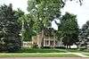 Inman House |
May 24, 1976 (#76001723) |
415 E. Main St. 42°46′45″N 96°55′31″W |
Vermillion | |
| 18 | Calle Nissen Johnsen Farm | Calle Nissen Johnsen Farm |
December 17, 1999 (#99001581) |
31494 453rd Ave. 42°49′26″N 97°08′24″W |
Gayville | |
| 19 | Jens N. and Anna Junker Farmstead | _from_S_1.JPG) Jens N. and Anna Junker Farmstead |
December 20, 1988 (#88002841) |
Norway Township, Section 6 42°48′46″N 97°08′57″W |
Norway Township | |
| 20 | Lincoln School No. 12 | _from_SE_1.JPG) Lincoln School No. 12 |
August 16, 2000 (#00000995) |
45352 Timber Rd. 42°47′39″N 97°07′50″W |
Meckling | |
| 21 | Linden House | 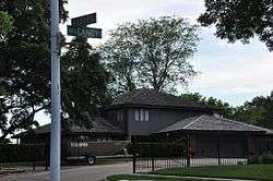 Linden House |
September 14, 2001 (#01001001) |
509 Linden Ave. 42°46′26″N 96°55′24″W |
Vermillion | |
| 22 | Daniel A. Messler Homestead | February 14, 2002 (#02000022) |
30337 Greenfield Rd. 42°59′36″N 96°50′59″W |
Beresford | ||
| 23 | Old Armory-Vermillion | Old Armory-Vermillion |
October 31, 2002 (#02001285) |
414 E. Clark St. 42°47′03″N 96°55′31″W |
Vermillion | Now the Belbas Center on the campus of the University of South Dakota. |
| 24 | Old Main |  Old Main |
March 24, 1973 (#73001738) |
Clark St. on the University of South Dakota campus 42°47′02″N 96°55′26″W |
Vermillion | |
| 25 | Prentis Park | 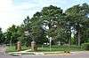 Prentis Park |
November 8, 2001 (#01001218) |
Plum and Main Sts. 42°46′53″N 96°55′05″W |
Vermillion | |
| 26 | Rice Farm | January 20, 1978 (#78002544) |
West of Vermillion 42°53′47″N 97°01′11″W |
Vermillion | ||
| 27 | St. Agnes Catholic Church | 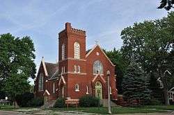 St. Agnes Catholic Church |
March 27, 1995 (#95000280) |
202 Washington St. 42°46′54″N 96°56′04″W |
Vermillion | Now an arts center. |
| 28 | Sample-Lindblaum House |  Sample-Lindblaum House |
December 2, 1998 (#98001405) |
410 Idaho St. 43°00′15″N 97°06′29″W |
Wakonda | |
| 29 | South Dakota Department of Trans. Br. No. 14-130-176 | 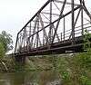 South Dakota Department of Trans. Br. No. 14-130-176 |
November 8, 2001 (#01001220) |
Local road over the Vermillion River 42°49′47″N 96°54′16″W |
Vermillion | |
| 30 | South Dakota Department of Trans. Br. No. 14-133-170 | 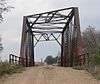 South Dakota Department of Trans. Br. No. 14-133-170 |
November 8, 2001 (#01001222) |
Local road over the Vermillion River 42°50′14″N 96°53′44″W |
Vermillion | |
| 31 | South Dakota Department of Transportation Bridge No. 14-060-032 | _from_SW_1.JPG) South Dakota Department of Transportation Bridge No. 14-060-032 |
January 28, 2000 (#00000020) |
Local road over Spring Creek 43°02′19″N 97°02′32″W |
Wakonda | Apparently no longer extant[6] |
| 32 | South Dakota Department of Transportation Bridge No. 14-088-170 | 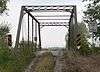 South Dakota Department of Transportation Bridge No. 14-088-170 |
January 14, 2000 (#99001689) |
Local road over Clay Creek Ditch 42°50′14″N 96°59′19″W |
Vermillion | |
| 33 | South Dakota Department of Transportation Bridge No. 14-090-042 | January 14, 2000 (#99001700) |
Local road over the Vermillion River 43°01′23″N 96°58′58″W |
Wakonda | ||
| 34 | Spirit Mound | 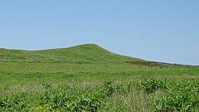 Spirit Mound |
November 19, 1974 (#74001889) |
North of Vermillion 42°52′32″N 96°57′32″W |
Vermillion | |
| 35 | University Historic District | 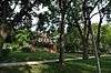 University Historic District |
February 24, 1975 (#75001714) |
Bounded by N. Yale, E. Clark, Willow, and E. Main Sts. 42°46′52″N 96°55′27″W |
Vermillion | Named "Vermillion Historic District" until September 1, 2015 |
| 36 | Vermillion-Andrew Carnegie Library | 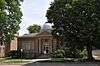 Vermillion-Andrew Carnegie Library |
August 18, 1983 (#83003006) |
12 Church St. 42°46′43″N 96°55′49″W |
Vermillion | |
| 37 | Wakonda State Bank | _from_NE_1.JPG) Wakonda State Bank |
August 15, 2003 (#03000765) |
118 Ohio St. 43°00′31″N 97°06′26″W |
Wakonda | |
| 38 | E.H. Willey House | 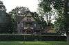 E.H. Willey House |
June 17, 1982 (#82003922) |
104 Court St. 42°46′41″N 96°55′54″W |
Vermillion | |
| 39 | Yusten House | January 23, 2007 (#06001310) |
30831 Highway 19 42°55′20″N 96°57′17″W |
Vermillion |
Former listings
| [3] | Name on the Register | Image | Date listed | Date removed | Location | City or town | Summary |
|---|---|---|---|---|---|---|---|
| 1 | South Dakota Department of Transportation Bridge No. 14-105-209 | January 14, 2000 (#99001690) | March 26, 2008 | Local Road over Chicago, Milwaukee, St. Paul and Pacific Railroad tracks |
Vermillion | ||
| 2 | South Dakota Department of Transportation Bridge No. 14-120-222 | September 29, 1999 (#99001218) | March 26, 2008 | Local road over Ash Creek |
Vermillion |
gollark: It would not then be fair to assume that differences are down to some inherent badness of Sri Lanka, but that doesn't make comparisons invalid.
gollark: You can absolutely compare the economy of Sri Lanka and developed place #something. We have many metrics for this.
gollark: Dismissing problems because other things have problems is the problem.
gollark: The problem there is not the comparing though!
gollark: I did retroactively.
See also
| Wikimedia Commons has media related to National Register of Historic Places in Clay County, South Dakota. |
References
- The latitude and longitude information provided in this table was derived originally from the National Register Information System, which has been found to be fairly accurate for about 99% of listings. Some locations in this table may have been corrected to current GPS standards.
- "National Register of Historic Places: Weekly List Actions". National Park Service, United States Department of the Interior. Retrieved on August 14, 2020.
- Numbers represent an ordering by significant words. Various colorings, defined here, differentiate National Historic Landmarks and historic districts from other NRHP buildings, structures, sites or objects.
- "National Register Information System". National Register of Historic Places. National Park Service. April 24, 2008.
- The eight-digit number below each date is the number assigned to each location in the National Register Information System database, which can be viewed by clicking the number.
- See photos of box culvert, bearing date "2009", at Commons:Category:Spring Creek bridge, 458 Avenue (Clay County, South Dakota)
| Topics | |
|---|---|
| Lists by state |
|
| Lists by insular areas | |
| Lists by associated state | |
| Other areas | |
| Related | |
| |
Municipalities and communities of Clay County, South Dakota, United States | ||
|---|---|---|
| Cities | | |
| Town | ||
| Unincorporated communities |
| |
| Footnotes | ‡This populated place also has portions in an adjacent county or counties | |
This article is issued from Wikipedia. The text is licensed under Creative Commons - Attribution - Sharealike. Additional terms may apply for the media files.