National Register of Historic Places listings in Big Horn County, Montana
This is a list of the National Register of Historic Places listings in Big Horn County, Montana. It is intended to be a complete list of the properties and districts on the National Register of Historic Places in Big Horn County, Montana, United States. The locations of National Register properties and districts for which the latitude and longitude coordinates are included below, may be seen in a map.[1]
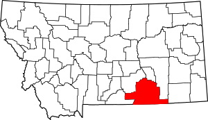
Location of Big Horn County in Montana
There are 39 properties and districts listed on the National Register in the county, including 2 National Historic Landmarks.
- This National Park Service list is complete through NPS recent listings posted August 14, 2020.[2]
Current listings
| [3] | Name on the Register | Image | Date listed[4] | Location | City or town | Description |
|---|---|---|---|---|---|---|
| 1 | Annashisee Iisaxpuatahcheeaashisee-Medicine Wheel on Bighorn River | March 25, 1999 (#99000343) |
3 miles (4.8 km) north of Fort Smith on the Bighorn River[5] 45°20′06″N 107°54′12″W |
Fort Smith | ||
| 2 | Baldwin House | August 3, 1987 (#87001270) |
25 3rd Ave. 45°19′02″N 107°22′00″W |
Lodge Grass | ||
| 3 | Bighorn Ditch Headgate | 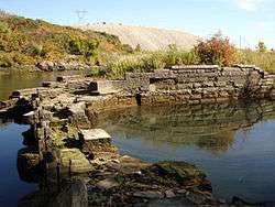 Bighorn Ditch Headgate |
December 12, 1976 (#76000174) |
West of Fort Smith at the mouth of Bighorn Canyon 45°18′56″N 107°57′03″W |
Fort Smith | |
| 4 | John Boyum House |  John Boyum House |
April 11, 1991 (#91000371) |
225 W. 6th St. 45°44′05″N 107°36′35″W |
Hardin | |
| 5 | Thomas H. Burke House |  Thomas H. Burke House |
April 11, 1991 (#91000368) |
604 N. Cody 45°44′04″N 107°36′36″W |
Hardin | |
| 6 | Cammock's Hotel | August 30, 1987 (#87001271) |
28 N. Main St. 45°18′57″N 107°21′49″W |
Lodge Grass | ||
| 7 | Camp Four | January 21, 1992 (#91001940) |
11 miles northeast of Fort Smith on Fort Smith-Hardin County Road 45°24′50″N 107°53′43″W |
Fort Smith | ||
| 8 | Chief Plenty Coups (Alek-Chea-Ahoosh) House | .jpg) Chief Plenty Coups (Alek-Chea-Ahoosh) House |
October 6, 1970 (#70000354) |
1 mile west of Pryor off Montana Highway 416 45°25′44″N 108°32′45″W |
Pryor | |
| 9 | Chivers Memorial Church | August 3, 1987 (#87001272) |
East of the former CB&Q railroad tracks, along the western side of U.S. Route 87 45°18′51″N 107°21′40″W |
Lodge Grass | ||
| 10 | Commercial District | _001.jpg) Commercial District |
August 14, 1985 (#85001845) |
Roughly bounded by 4th, Crook, the Burlington Northern line, 1st and Crow Sts. 45°43′46″N 107°36′30″W |
Hardin | |
| 11 | J.W. Drew Grain Elevator | August 3, 1987 (#87001274) |
Eastern side of Main St. 45°19′02″N 107°21′49″W |
Lodge Grass | ||
| 12 | William Ebeling House |  William Ebeling House |
April 11, 1991 (#91000370) |
704 N. Crow Ave. 45°44′08″N 107°36′31″W |
Hardin | |
| 13 | Charles S. Eder House |  Charles S. Eder House |
April 11, 1991 (#91000374) |
416 W. 3rd St. 45°43′53″N 107°36′43″W |
Hardin | |
| 14 | First Baptist Church | 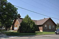 First Baptist Church |
April 11, 1991 (#91000369) |
524 N. Custer Ave. 45°44′03″N 107°36′26″W |
Hardin | |
| 15 | Fort C.F. Smith Historic District | October 10, 1975 (#75000163) |
East of Fort Smith in the Bighorn Canyon National Recreation Area 45°17′59″N 107°54′59″W |
Fort Smith | ||
| 16 | Haverfield Hospital |  Haverfield Hospital |
April 11, 1991 (#91000376) |
520 W. 3rd St. 45°43′52″N 107°36′51″W |
Hardin | |
| 17 | Francis Kopriva House |  Francis Kopriva House |
April 11, 1991 (#91000377) |
416 Crawford Ave. 45°43′58″N 107°36′41″W |
Hardin | |
| 18 | Lee Homestead | July 8, 1981 (#81000659) |
Northeast of Decker in Tongue River Reservoir State Park 45°08′00″N 106°45′52″W |
Decker | Probably demolished. | |
| 19 | Little Bighorn Battlefield National Monument | 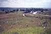 Little Bighorn Battlefield National Monument |
October 15, 1966 (#66000428) |
15 miles south of Hardin 45°31′20″N 107°22′39″W |
Hardin | |
| 20 | Lodge Grass City Jail | August 3, 1987 (#87001276) |
Alley south of 3rd Ave. 45°19′01″N 107°21′53″W |
Lodge Grass | ||
| 21 | Lodge Grass Merchandise Company Store | August 3, 1987 (#87001275) |
1st Ave. 45°18′55″N 107°21′54″W |
Lodge Grass | ||
| 22 | Moncure Tipi |  Moncure Tipi |
December 20, 2002 (#02001547) |
Montana Highway 212 45°31′46″N 106°57′28″W |
Busby | |
| 23 | OW Ranch | December 15, 1992 (#92001321) |
Roughly 15 miles south of Birney on Hanging Woman Creek 45°08′10″N 106°28′39″W |
Birney | ||
| 24 | George Pease's Second Store | August 3, 1987 (#87001278) |
8 N. Main St. 45°18′57″N 107°21′49″W |
Lodge Grass | ||
| 25 | J.J. Ping House |  J.J. Ping House |
April 11, 1991 (#91000373) |
119 W. 6th St. 45°44′04″N 107°36′26″W |
Hardin | |
| 26 | Reno Apartments |  Reno Apartments |
April 11, 1991 (#91000378) |
719 N. Custer Ave. 45°44′08″N 107°37′10″W |
Hardin | |
| 27 | Residential District |  Residential District |
August 14, 1985 (#85001846) |
Roughly bounded by 5th, 4th, Crow, and Cody 45°43′56″N 107°36′28″W |
Hardin | |
| 28 | Rosebud Battlefield-Where the Girl Saved Her Brother |  Rosebud Battlefield-Where the Girl Saved Her Brother |
August 21, 1972 (#72000735) |
Montana Highway 314, 12 miles south of Kirby 45°13′17″N 106°59′21″W |
Kirby | |
| 29 | John Ryan's House | August 3, 1987 (#87001277) |
15 N. Helen St. 45°18′51″N 107°21′50″W |
Lodge Grass | ||
| 30 | St. Joseph Catholic Church | 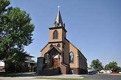 St. Joseph Catholic Church |
April 11, 1991 (#91000379) |
710 N. Custer Ave. 45°44′09″N 107°36′26″W |
Hardin | |
| 31 | St. Xavier Mission Church and Rectory |  St. Xavier Mission Church and Rectory |
August 17, 1990 (#90001214) |
On the Big Horn River in the Crow Indian Reservation 45°27′48″N 107°43′37″W |
St. Xavier | |
| 32 | Jay Sharp's Store | August 3, 1987 (#87001279) |
18 Helen St. 45°18′53″N 107°21′53″W |
Lodge Grass | ||
| 33 | Simmonsen's House | August 3, 1987 (#87001273) |
4 S. George St. 45°18′49″N 107°22′05″W |
Lodge Grass | ||
| 34 | Dominic Stevens House | August 3, 1987 (#87001280) |
10 W. Hester Ave. 45°18′49″N 107°22′03″W |
Lodge Grass | ||
| 35 | Sullivan Rooming House |  Sullivan Rooming House |
April 11, 1991 (#91000372) |
217 W. Sixth St. 45°44′05″N 107°36′34″W |
Hardin | |
| 36 | James J. Sullivan House | 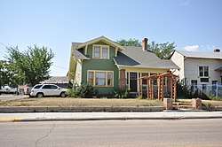 James J. Sullivan House |
April 11, 1991 (#91000380) |
220 W. 3rd St. 45°43′52″N 107°36′32″W |
Hardin | |
| 37 | J.M. Trytten House | August 3, 1987 (#87001281) |
George St. 45°18′50″N 107°22′05″W |
Lodge Grass | ||
| 38 | J.S. Tupper House |  J.S. Tupper House |
April 11, 1991 (#91000381) |
502 N. Cody 45°44′01″N 107°36′39″W |
Hardin | |
| 39 | Alvin Young Barn and Cabin Historic District | January 25, 2011 (#10001188) |
Rosebud Battlefield Rd., 3 miles west of MT 314 45°12′55″N 107°00′22″W |
Busby vicinity |
Former listings
| [3] | Name on the Register | Image | Date listed | Date removed | Location | City or town | Summary |
|---|---|---|---|---|---|---|---|
| 1 | Wilber Fish House | April 11, 1991 (#91000375) | April 14, 1992 | 620 Crow Ave. |
Hardin |
gollark: Probably.
gollark: Rust could have a four loop macro.
gollark: ```haskellf x = error "kernel panic"```
gollark: ```haskellf x = undefined```
gollark: ```haskellf = unsafeCoerce```
See also
| Wikimedia Commons has media related to National Register of Historic Places in Big Horn County, Montana. |
- List of National Historic Landmarks in Montana
- National Register of Historic Places listings in Montana
- Montana History Wiki section on National Register of Historic Places sign texts for Big Horn County.
References
- The latitude and longitude information provided in this table was derived originally from the National Register Information System, which has been found to be fairly accurate for about 99% of listings. Some locations in this table may have been corrected to current GPS standards.
- "National Register of Historic Places: Weekly List Actions". National Park Service, United States Department of the Interior. Retrieved on August 14, 2020.
- Numbers represent an ordering by significant words. Various colorings, defined here, differentiate National Historic Landmarks and historic districts from other NRHP buildings, structures, sites or objects.
- The eight-digit number below each date is the number assigned to each location in the National Register Information System database, which can be viewed by clicking the number.
- Brown, Lionel A. "The Fort Smith Medicine Wheel, Montana". Plains Anthropologist 8.22 (1963): 225-230: 226.
| Topics | |
|---|---|
| Lists by state |
|
| Lists by insular areas | |
| Lists by associated state | |
| Other areas | |
| Related | |
| |
Municipalities and communities of Big Horn County, Montana, United States | ||
|---|---|---|
| City | Big Horn County map | |
| Town | ||
| CDPs | ||
| Unincorporated communities | ||
| Indian reservations | ||
| Footnotes | ‡This populated place also has portions in an adjacent county or counties | |
This article is issued from Wikipedia. The text is licensed under Creative Commons - Attribution - Sharealike. Additional terms may apply for the media files.