Nahetal-Waldau
Nahetal-Waldau is a former municipality in the district of Hildburghausen, in Thuringia, Germany. Since July 2018, it is part of the town Schleusingen.
Nahetal-Waldau | |
|---|---|
part of Schleusingen | |
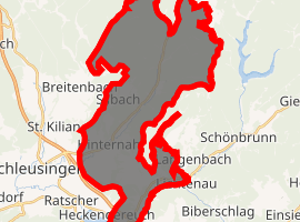
Location of Nahetal-Waldau 
| |
 Nahetal-Waldau  Nahetal-Waldau | |
| Coordinates: 50°31′9″N 10°47′51″E | |
| Country | Germany |
| State | Thuringia |
| District | Hildburghausen |
| Town | Schleusingen |
| Area | |
| • Total | 32.97 km2 (12.73 sq mi) |
| Elevation | 410 m (1,350 ft) |
| Population (2016-12-31) | |
| • Total | 2,997 |
| • Density | 91/km2 (240/sq mi) |
| Time zone | CET/CEST (UTC+1/+2) |
| Postal codes | 98553 |
| Dialling codes | 036841, 036878 |
| Vehicle registration | HBN |
| Website | www.nahetal-waldau.de |
Geography
Geographical Location
The municipality of Nahetal-Waldau was located in the Thuringian Forest. The districts of Waldau and Oberrod are located in the valley of the lock, and the hamlets of Schleusingerneundorf and Hinternah are located in the Nahe Valley.
Community
The districts in the municipality were:
- Hinternah
- Oberrod
- Schleusingerneundorf
- Silbach
- Waldau
gollark: * around a word means "italicize it" in Markdwon.
gollark: It's *.
gollark: This is not very accurate, though.
gollark: In a market, if people don't want kale that much, the kale company will probably not have much money and will not be able to buy all the available fertilizer.
gollark: You can just hand out what some random people think is absolutely *needed* first, then stick the rest of everything up for public use, but that won't work either! Someone has to decide on the "needed", so you get into a planned-economy sort of situation, and otherwise... what happens when, say, the community kale farm decides they want all the remaining fertilizer, even when people don't want *that* much kale?
References
External links
| Wikimedia Commons has media related to Nahetal-Waldau. |
This article is issued from Wikipedia. The text is licensed under Creative Commons - Attribution - Sharealike. Additional terms may apply for the media files.