Na Yia District
Na Yia (Thai: นาเยีย, pronounced [nāː jīa̯]) is a district (amphoe) in the central part of Ubon Ratchathani Province, northeastern Thailand.
Na Yia นาเยีย | |
|---|---|
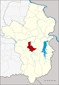 Districtlocation in Ubon Ratchathani Province | |
| Coordinates: 15°3′34″N 105°3′37″E | |
| Country | Thailand |
| Province | Ubon Ratchathani |
| Seat | Na Yia |
| Area | |
| • Total | 227.0 km2 (87.6 sq mi) |
| Population (2005) | |
| • Total | 24,970 |
| • Density | 110.0/km2 (285/sq mi) |
| Time zone | UTC+7 (ICT) |
| Postal code | 34160 |
| Geocode | 3429 |
History
Na Yia was separated from Det Udom District to create a minor district (king amphoe) on 31 May 1993.[1]
On 15 May 2007, all 81 minor districts were upgraded to full districts.[2] On 24 August the upgrade became official.[3]
Geography
Neighboring districts are (from the north clockwise) Sawang Wirawong, Phibun Mangsahan, Det Udom and Warin Chamrap.
Administration
The district is divided into three sub-districts (tambons), which are further subdivided into 34 villages (mubans). Na Yia is a township (thesaban tambon) which covers parts of tambon Na Yia. There are a further three tambon administrative organizations (TAO).
| No. | Name | Thai name | Villages | Pop. | |
|---|---|---|---|---|---|
| 1. | Na Yia | นาเยีย | 12 | 11,750 | |
| 2. | Na Di | นาดี | 13 | 6,898 | |
| 3. | Na Rueang | นาเรือง | 9 | 6,322 |
gollark: But even then I just judge their consumer lineup.
gollark: Except Lenovo. They deliberately installed adware.
gollark: I try to not judge entire large complex brands by one bad product.
gollark: Acer TravelMate P4 TMP449-G2-M with aftermarket 120GB SSD + 4GB RAM DIMM.
gollark: Only one slot, mind you.
References
- ประกาศกระทรวงมหาดไทย เรื่อง แบ่งเขตท้องที่อำเภอเดชอุดม จังหวัดอุบลราชธานี ตั้งเป็นกิ่งอำเภอนาเยีย (PDF). Royal Gazette (in Thai). 110 (74 ง): 17. June 8, 1993.
- แถลงผลการประชุม ครม. ประจำวันที่ 15 พ.ค. 2550 (in Thai). Manager Online.
- พระราชกฤษฎีกาตั้งอำเภอฆ้องชัย...และอำเภอเหล่าเสือโก้ก พ.ศ. ๒๕๕๐ (PDF). Royal Gazette (in Thai). 124 (46 ก): 14–21. August 24, 2007.
This article is issued from Wikipedia. The text is licensed under Creative Commons - Attribution - Sharealike. Additional terms may apply for the media files.