Murara
Murara was a small, short-lived, cinder cone on the flank of Mount Nyamuragira, that began erupting on December 23, 1976. Eruptions from Murara reduced considerably after the eruption of Mount Nyiragongo on January 10, 1977 and ended completely in April 1977.
| Murara | |
|---|---|
| Highest point | |
| Elevation | less than 3,058 metres (10,033 feet) |
| Coordinates | 1°24′30″S 29°12′0″E |
| Geography | |
| Location | Democratic Republic of the Congo |
| Parent range | Virunga Mountains |
| Geology | |
| Mountain type | Cinder cone |
| Last eruption | 1977 |
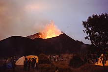
Erupting cinder cone volcano in background, with temporary tourist camp in foreground.
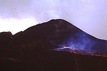
Lava flow in the foreground with the outline of the Murara cinder cone in the background
During the Christmas and New Year holiday period, the Virunga National Park authorities organised a temporary camp, within a few hundred metred of Murara, so that visitors could observe the eruption and lava flow.
References
- "Nyamuragira". Global Volcanism Program. Smithsonian Institution. Retrieved 2008-04-09.
- "Nyamuragira - Monthly Reports (SEAN 02:03)". Global Volcanism Program. Smithsonian Institution. Retrieved 2008-04-09.
This article is issued from Wikipedia. The text is licensed under Creative Commons - Attribution - Sharealike. Additional terms may apply for the media files.