Mueang Roi Et District
Mueang Roi Et (Thai: เมืองร้อยเอ็ด, pronounced [mɯ̄a̯ŋ rɔ́ːj ʔèt]) is the capital district (amphoe mueang) in the western part of Roi Et Province, northeastern Thailand.
Mueang Roi Et เมืองร้อยเอ็ด | |
|---|---|
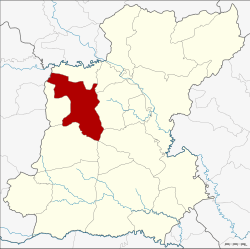 District location in Roi Et Province | |
| Coordinates: 16°3′12″N 103°39′12″E | |
| Country | Thailand |
| Province | Roi Et |
| Area | |
| • Total | 493.6 km2 (190.6 sq mi) |
| Population (2005) | |
| • Total | 153,567 |
| • Density | 311.1/km2 (806/sq mi) |
| Time zone | UTC+7 (ICT) |
| Postal code | 45000 |
| Geocode | 4501 |
History
Mueang Roi Et is an ancient city. The area around the city was made into a district in 1908. In 1913 its name was changed from Pachin Roi Et to Mueang Roi Et.[1]
Geography
Neighboring districts are (from the north clockwise): Changhan, Chiang Khwan, Thawat Buri, At Samat, Mueang Suang (at a single point), Chaturaphak Phiman and Si Somdet of Roi Et Province; and Mueang Maha Sarakham of Maha Sarakham Province.
Administration
The district is divided into 15 sub-districts (tambons), which are further subdivided into 195 villages (mubans). Roi Et is a town (thesaban mueang) which covers the whole of tambon Nai Mueang. There are a further 14 tambon administrative organizations (TAO).
| No. | Name | Thai name | Villages | Pop. | |
|---|---|---|---|---|---|
| 1. | Nai Mueang | ในเมือง | - | 34,285 | |
| 2. | Rop Mueang | รอบเมือง | 20 | 15,569 | |
| 3. | Nuea Mueang | เหนือเมือง | 21 | 19,797 | |
| 4. | Khon Kaen | ขอนแก่น | 14 | 7,310 | |
| 5. | Na Pho | นาโพธิ์ | 10 | 4,718 | |
| 6. | Sa-at Sombun | สะอาดสมบูรณ์ | 16 | 8,584 | |
| 8. | Si Kaeo | สีแก้ว | 20 | 12,769 | |
| 9. | Po Phan | ปอภาร (ปอพาน) | 13 | 7,547 | |
| 10. | Non Rang | โนนรัง | 9 | 5,603 | |
| 17. | Nong Kaeo | หนองแก้ว | 13 | 6,860 | |
| 18. | Nong Waeng | หนองแวง | 15 | 8,137 | |
| 20. | Dong Lan | ดงลาน | 13 | 7,755 | |
| 23. | Khaen Yai | แคนใหญ่ | 11 | 4,439 | |
| 24. | Non Tan | โนนตาล | 10 | 4,977 | |
| 25. | Mueang Thong | เมืองทอง | 10 | 5,217 |
Missing numbers are tambons which now form the Changhan and Si Somdet Districts.
References
- แจ้งความกระทรวงมหาดไทย เรื่อง เปลี่ยนนามอำเภอ (PDF). Royal Gazette (in Thai). 30 (0 ง): 1619–1620. October 19, 1913.