Mount Pontida
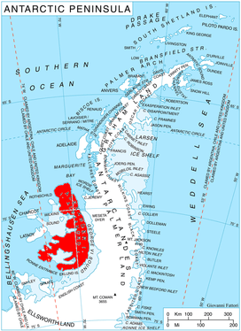
Mount Pontida (Bulgarian: връх Понтида, romanized: vrah Pontida, IPA: [ˈvrɤx ponˈtidɐ]) is the ice-covered mountain rising to 1700 m in Havre Mountains, northern Alexander Island in Antarctica. It surmounts Hadzhiev Glacier to the north, Foreman Glacier to the southeast and Wubbold Glacier to the southwest. British mapping in 1971. The feature is named after the hypothetical lost land of Pontida located in Black Sea.
Location
The mountain is located at 69°14′17.7″S 71°32′51″W, which is 14.65 km east of Simon Peak, 5.42 km southeast of Igralishte Peak, 8.26 km southwest of Mount Newman, 5.7 km west of Dimitrova Peak and 19.2 km north-northeast of Mount Holt.
Maps
- British Antarctic Territory. Scale 1:200000 topographic map. DOS 610 – W 69 70. Tolworth, UK, 1971
- Antarctic Digital Database (ADD). Scale 1:250000 topographic map of Antarctica. Scientific Committee on Antarctic Research (SCAR). Since 1993, regularly upgraded and updated
References
- Bulgarian Antarctic Gazetteer. Antarctic Place-names Commission. (details in Bulgarian, basic data in English)
- Mount Pontida. SCAR Composite Gazetteer of Antarctica
External links
- Mount Pontida. Copernix satellite image
This article includes information from the Antarctic Place-names Commission of Bulgaria which is used with permission.