Mount Nyū
Mount Nyū (乳, Nyū) is a stratovolcano of the Northern Yatsugatake Volcanic Group in Koumi, Nagano Prefecture, Japan. This mountain is part of the Yatsugatake-Chūshin Kōgen Quasi-National Park.
| Mount Nyū | |
|---|---|
| 乳/ニュウ | |
 Mount Nyū (July 2008) | |
| Highest point | |
| Elevation | 2,351.9 m (7,716 ft) |
| Listing | List of mountains and hills of Japan by height |
| Coordinates | 36°2′22″N 138°22′14″E |
| Naming | |
| Language of name | Japanese |
| Pronunciation | [njuː] |
| Geography | |
| Location | Koumi, Nagano, Japan |
| Parent range | Northern Yatsugatake Volcanic Group |
| Geology | |
| Mountain type | Stratovolcano |
Climbing route
There are several routes to reach to the top of Mount Nyū. One is from Shirokoma Pond, it takes one and half hours. Another major route is from Mount Naka.
Access
- Shirokomaike-iriguchi Bus Stop of Chikuma Bus
- Mugikusa-toge Bus Stop of Chikuma Bus
Gallery
- Mount Nyū and Mount Naka.
 Mount Tateshina , Mount Kitayoko and Shirokoma Pond from Mount Nyū
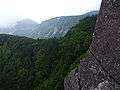 Mount Iō from Mount Nyū
 East side view from the top of Mount Nyū
 Southeast side view the top of Mount Nyū
 At the route to Mount Nyū (1)
 At the route to Mount Nyū (2)
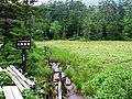 Shirakoma Moor on the way to Mount Nyū
gollark: Well, it has text which is recognizable as numbers.
gollark: It won't be *exact*, being an image and all, but you could probably do "close enough". You would need a lot more resolution on the circle to display it well than the rectangle, though.
gollark: I'm beginning to think that it might be easier to just hand-write SVGs.
gollark: Here's an incredibly bad diagram. I need an image editor for Linux which actually works.
gollark: Take each pixel of the input and its X/Y coordinates, divide the circle up into an equal amount of "pixels" using polar coordinates, and map them on.
References
This article is issued from Wikipedia. The text is licensed under Creative Commons - Attribution - Sharealike. Additional terms may apply for the media files.