Mount Malaueg
Mount Malaueg was known to be the most historic mountain of Malaueg. The mountain was also known the Gigantic Plateau of Malaueg since its only location was a plateau and the place was said to be the treasure keeping of the Spaniards dating four centuries ago. The name of the mountain was derived from their dialect which means "Bad Brook" and the peak of the mountain was said to be the bridge between Poblacion and Capacuan, Rizal, Cagayan.
| Mount Malaueg | |
|---|---|
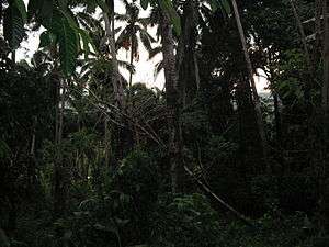 Mt. Malaueg Rainforest | |
| Highest point | |
| Elevation | 1,092.9 m (3,586 ft) |
| Coordinates | 17°50′35″N 121°21′08″E |
| Naming | |
| Language of name | Filipino |
| Pronunciation | Ma-Lou-eg |
| Geography | |
.svg.png) Mount Malaueg Philippines | |
| Location | Rizal, Cagayan, Philippines |
| Parent range | Cordillera Mountain Range |
| Geology | |
| Mountain type | Plateau |
| Climbing | |
| Easiest route | Rizal, Cagayan |
Overview of the area
The plateau is located at the southern to western part of the town's center. It has a total length of almost 3 kilometers from the opposite of Mount. Maoanan adjacent to Mount. Annaguan. It has the highest recorded peak of 1092.9 meters and the lowest elevation is 530 meters. Lying on the foot of the mountain is the flowing Matalag River yet the only way to get on the mountain is to cross the certain river or go directly to the barangay of Maoanan yet it's connected with the foot of Mount. Maoanan.
Name
The name of the mountain was named by the people of the certain town many centuries later. It was also said that the mountain was where the fairy in the legend of Biuag and Malana stood still and it was also said it was the nature sanctuary that is about to be developed.
References