Mount Llana
Mount Llana (Bulgarian: връх Ляна, romanized: vrah Lyana, IPA: [ˈvrɤx ˈʎanɐ]) is the ice-covered peak rising to 1300 m at the north extremity of Urda Ridge on Clarence Island in the South Shetland Islands, Antarctica. It is connected to Jerez Peak by Soyka Saddle, and surmounts Bersame Glacier to the west and Highton Glacier to the east.

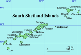
Location of Clarence Island in the South Shetland Islands.
The peak is named after the Spanish mariner José de la Llana who probably discovered Shag Rocks, South Georgia in 1762.
Location
Mount Llana is located at 61°14′46″S 54°07′17″W, which is 3.68 km north of Mount Irving and 2 km south-southwest of Jerez Peak. British mapping in 1972 and 2009.
Maps
- British Antarctic Territory. Scale 1:200000 topographic map. DOS 610 Series, Sheet W 61 54. Directorate of Overseas Surveys, Tolworth, UK, 1972.
- South Shetland Islands: Elephant, Clarence and Gibbs Islands. Scale 1:220000 topographic map. UK Antarctic Place-names Committee, 2009.
- Antarctic Digital Database (ADD). Scale 1:250000 topographic map of Antarctica. Scientific Committee on Antarctic Research (SCAR). Since 1993, regularly upgraded and updated.
gollark: The trick is to never incubate anything, or to run out of reds.
gollark: For once I can actually catch the stupid things; less competition or whatever.
gollark: Two rainbows.
gollark: No, I'm not being sarcastic, the coppers are amazing.
gollark: Sarcastic about what/
References
- Bulgarian Antarctic Gazetteer. Antarctic Place-names Commission. (details in Bulgarian, basic data in English)
- Mount Llana. SCAR Composite Gazetteer of Antarctica
External links
- Mount Llana. Copernix satellite image
This article includes information from the Antarctic Place-names Commission of Bulgaria which is used with permission.
This article is issued from Wikipedia. The text is licensed under Creative Commons - Attribution - Sharealike. Additional terms may apply for the media files.