Mount Inverleith
Mount Inverleith (64°55′S 62°45′W) is a mountain, 1,495 meters (4,900 ft) high, overlooking Andvord Bay, located roughly five miles due south of the bay's southern shoreline (Lester Cove). Mount Inverleith is flanked by Dallmeyer Peak to the north and by the Grubb Glacier and Bagshawe Glaciers to the west.
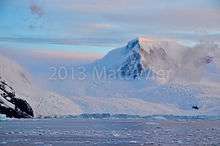
Mount Inverleith - sunset over Neko Harbor, Antarctic Peninsula
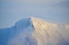
Windswept summit of Mount Inverleith
It is located roughly 9.5 miles southwest of Brown Station, on Danco Coast in western Graham Land, Antarctica.
The mountain was first charted and named "Iverleith Hill" by Scottish geologist David Ferguson in 1913–14.[1]
References
- "Inverleith, Mount". Geographic Names Information System. United States Geological Survey. Retrieved 2012-07-09.
![]()
This article is issued from Wikipedia. The text is licensed under Creative Commons - Attribution - Sharealike. Additional terms may apply for the media files.