Mount Hight
Mount Hight is a mountain located in Coos County, New Hampshire. The mountain is part of the Carter-Moriah Range of the White Mountains, which runs along the eastern-northeastern side of Pinkham Notch. Mount Hight is flanked on the north by South Carter Mountain across Zeta Pass, and on the southwest by Carter Dome.
| Mount Hight | |
|---|---|
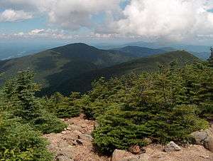 The bare summit of Mount Hight to the right; Middle Carter Mountain to the left. | |
| Highest point | |
| Elevation | 4,675 ft (1,425 m) |
| Prominence | 125 ft (38 m) |
| Coordinates | 44°16′33″N 071°10′11″W |
| Geography | |
| Location | Coös County, New Hampshire, U.S. |
| Parent range | Carter-Moriah Range |
| Topo map | USGS Carter Dome |
Although well over 4,000 feet (1,200 m) in height, the Appalachian Mountain Club does not consider Hight a "four-thousand footer" because the col on the ridge from Carter Dome only descends 125 ft (38 m), making it a secondary summit of that peak. However, the bare summit of Mount Hight has the best views of any summit of the Carter-Moriah Range. Conversely, Carter Dome, the highest peak in the range, is wooded and has only limited views.
See also
- List of mountains in New Hampshire
- White Mountain National Forest
External links