Mount Harmston
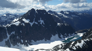
Mount Harmston is a mountain on Vancouver Island, British Columbia, Canada, located approximately 33 km (21 mi) southwest of Courtenay and 3 km (2 mi) north of The Red Pillar.
| Mount Harmston | |
|---|---|
 | |
| Highest point | |
| Elevation | 2,009 m (6,591 ft) |
| Prominence | 375 m (1,230 ft) |
| Coordinates | 49°32′56.0″N 125°23′53.9″W |
| Geography | |
| Location | Vancouver Island, British Columbia, Canada |
| Parent range | Vancouver Island Ranges |
| Topo map | NTS 92/F11 |
Mount Harmston is part of the Vancouver Island Ranges which in turn form part of the Insular Mountains.[1]
History
Mount Harmston is named after the Harmston family, early settlers of the Comox Valley. They settled on a 200+ acre preemption in early December 1862, coming from Lincolnshire, England.[2]
gollark: For too long, it has sat there in the sky, mocking us.
gollark: And I am all for it.
gollark: This is obviously part of the conspiracy to remove the Moon.
gollark: ↑ apparently they did that president's corruption trial via Teams
gollark: https://ichef.bbci.co.uk/live-experience/cps/624/cpsprodpb/vivo/live/images/2021/7/19/78aa3246-1bbd-4cc2-9ce3-92917c2ab509.png
References
- Mount Harmston in the Canadian Mountain Encyclopedia
- BC Geographical Names Information System, Mount Harmston
This article is issued from Wikipedia. The text is licensed under Creative Commons - Attribution - Sharealike. Additional terms may apply for the media files.