Mount Defiance (Oregon)
Mount Defiance is a peak near the Columbia River Gorge in the US state of Oregon. It rises to an elevation of 5,010 feet (1,527 m)[2] in the Mark O. Hatfield Wilderness on the Mount Hood National Forest. The peak is in Hood River County, Oregon. The route up the mountain is often considered one of the hardest climbs in the Gorge;[3] the trail gains 5,000 feet (1,500 m) in 6 miles (9.7 km) from the Starvation Creek Trailhead.[4]
| Mount Defiance | |
|---|---|
 Mount Defiance Location in Oregon | |
| Highest point | |
| Elevation | 5,010 ft (1,527 m) NAVD 88[1] |
| Prominence | 1,520 ft (463 m) [2] |
| Coordinates | 45°38′55″N 121°43′22″W [1] |
| Geography | |
| Location | Hood River County, Oregon, U.S. |
| Parent range | Cascades |
| Topo map | Mount Defiance |
Mount Defiance is composed chiefly of lava flows.[5] The base is basalt from an old shield volcano, and it is capped by andesite.[6]
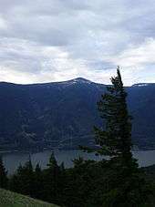
Mount Defiance from Dog Mountain
References
- "Mt Defiance". NGS data sheet. U.S. National Geodetic Survey. Retrieved 2016-05-01.
- "Mount Defiance, Oregon". Peakbagger.com. Retrieved 2013-01-17.
- "Mount Defiance". Friends of the Columbia Gorge. Retrieved 2016-05-01.
- "Starvation Creek State Park". Oregon Parks and Recreation Department. Retrieved 2016-05-01.
- Scott, W.E.; Pierson, T.C.; Schilling, S.P.; et al. (1997). "Volcano Hazards in the Mount Hood Region, Oregon" (PDF).
- Korosec, Michael (1987). "Geologic Map of the Hood River Quadrangle, Washington and Oregon" (PDF). Retrieved 2016-05-01.
External links
This article is issued from Wikipedia. The text is licensed under Creative Commons - Attribution - Sharealike. Additional terms may apply for the media files.