Mount Decoeli
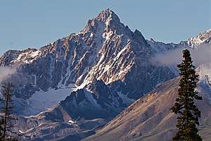
Mount Decoeli is a 2,332-metre (7,651-foot) pyramidal peak located in the Kluane Ranges of the Saint Elias Mountains in Yukon, Canada.[2] The mountain is situated 23 km (14 mi) northwest of Haines Junction, 21.4 km (13 mi) east of Mount Cairnes, and can be seen from the Alaska Highway midway between the two. Its nearest higher peak is Mount Archibald, 6 km (3.7 mi) to the south.[1] The mountain's name was officially adopted August 12, 1980, by the Geographical Names Board of Canada.[2] James J. McArthur was a Canadian surveyor and mountaineer who undertook extensive surveying in the Yukon during his later years. In 1908 he made the first ascent of Williams Peak accompanied by E. T. de Coeli.[4] Decoeli is pronounced deh-kal-eye.[1] To the Southern Tutchone people, the mountain is known as Nàday Gän, meaning Dried Lynx Mountain.[5]
| Mount Decoeli | |
|---|---|
 Mount Decoeli, northwest aspect | |
| Highest point | |
| Elevation | 2,332 m (7,651 ft) [1] |
| Prominence | 427 m (1,401 ft) [1] |
| Parent peak | Mount Archibald (3020 m)[1] |
| Coordinates | 60°50′13″N 137°53′18″W [2] |
| Geography | |
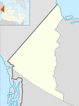
 Mount Decoeli Location in Yukon, Canada | |
| Location | Yukon, Canada |
| Parent range | Saint Elias Mountains[3] |
| Topo map | NTS 115A/13[2] |
| Climbing | |
| Easiest route | Scrambling via southeast face, and south ridge[1] |
Climbing the peak is a long strenuous day hike of 1,332-metre (4,370-foot) elevation gain over a distance of 18 km (11 mi) round trip, with a scramble via the south face and south ridge. On a clear day, the summit offers views into Kluane National Park of giants such as Mt. Logan, Mt. Vancouver, and Mt. Kennedy. A repeater is installed at the summit.[6]
Climate
Based on the Köppen climate classification, Mount Decoeli is located in a subarctic climate zone with long, cold, snowy winters, and mild summers.[7] The annual average temperature in the neighborhood is -6 ° C. The warmest month is July, when the average temperature is 8 °C, and the coldest is December when temperatures can drop below −20 °C with wind chill factors below −30 °C. Precipitation runoff from the peak and meltwater from its rock glacier drains into tributaries of the Kaskawulsh River.
References
- "Mount Decoeli". Bivouac.com. Retrieved 2019-12-08.
- "Mount Decoeli". Geographical Names Data Base. Natural Resources Canada. Retrieved 2019-12-08.
- "Mount Decoeli, Yukon Territory". Peakbagger.com. Retrieved 2019-12-08.
- "Williams Peak". Bivouac.com. Retrieved 2019-11-28.
- Yukon Place Names
- http://www.yara.ca/repeaters/repeaters_Decoeli.htm
- Peel, M. C.; Finlayson, B. L. & McMahon, T. A. (2007). "Updated world map of the Köppen−Geiger climate classification". Hydrol. Earth Syst. Sci. 11: 1633–1644. ISSN 1027-5606.
External links
- Parks Canada: Climbing route Mt. Decoeli
- Weather forecast: Mount Decoeli
- Views from the peak: adventuresoflupe.com