Mount Bental/Tal Al-Gharam
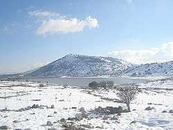
Mount Bental (Arabic: جبل بنطل, جبل الغرام / ALA-LC: Jabal al-Gharam / "Mountain of Lust" "Jabal Bental"; Hebrew: הר בנטל, Har Bental, "Mount Bental") is a dormant volcano in the North-Eastern part of the Golan Heights, It extends to an elevation of 1,171 Meters above sea level.
| Mount Bental/Tal Al-Gharam | |
|---|---|
| جبل بنطل, جبل الغرام (in Arabic) הר בנטל (in Hebrew) | |
 Mount Bental | |
| Highest point | |
| Elevation | 1,171 m (3,842 ft) |
| Coordinates | 33°7′41″N 35°47′8″E |
| Geography | |
 Mount Bental/Tal Al-Gharam Mount Bental | |
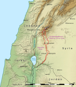
| Location | Golan Heights |
| Geology | |
| Mountain type | Volcano |
Geology
The mountain is a part of a chain of dormant volcanic mountains spanning along the eastern part of the Golan Heights starting from Mount Ram in the north and ending on Tal Saki in the south, it is the northern neighbor of Mount Avital which shares the same volcanic magma source with it. Mount Bental was formed in a volcanic eruption which formed a scoria volcanic cone, the magma which tried to erupt from Mount Avital's top could not do so and the pressure lead to an eruption of the western side of Mount Avital and of Mount Bental.
The Mountain
Mount Bental is covered with Quercus calliprinos trees and on its top, there is an IDF stronghold which was built on an older Syrian stronghold which is an attraction point for visitors. The mountain top has a good view of the Syrian lands, Mount Hermon and the Golan Heights.
Merom Golan is located at the bottom of the volcanic crater.[1]
Attractions
The mountain sits at the top of a car trail where families can stop and buy local Druze treats and food and eat at the Coffee Anan restaurant. It is a pun on the former UN secretary's name, as Anan means cloud in Hebrew and the restaurant is on the peak of the mountain. On the mountain, there are 2 trails. One above ground and one under. The underground trail is an old IDF bunker which tells the story of the Yom Kippur war using Wall art. At the end of both trails there is an UN Observation post.
References
| Wikimedia Commons has media related to Mount Bental. |