Monte Zucchero
Monte Zucchero (Italian pronunciation: [ˈmonte ˈdzukkero]) is a mountain in the Lepontine Alps of Switzerland. It is located between Bignasco and Sonogno in the canton of Ticino. Reaching a height of 2,735 metres above sea level, Monte Zucchero is the highest summit on the range south of the Passo di Redorta, that separates the Valle Maggia from the Valle Verzasca.
| Monte Zucchero | |
|---|---|
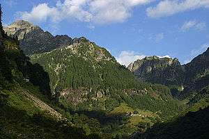 Monte Zucchero (left) from the Val Redorta | |
| Highest point | |
| Elevation | 2,735 m (8,973 ft) |
| Prominence | 554 m (1,818 ft) [1] |
| Parent peak | Dammastock |
| Isolation | 2.67 km (1.66 mi) |
| Coordinates | 46°21′15″N 8°42′51″E |
| Geography | |
 Monte Zucchero Location in Switzerland | |
| Location | Ticino, Switzerland |
| Parent range | Lepontine Alps |
References
- Retrieved from the Swisstopo topographic maps. The key col is the Passo di Redòrta (2,181 m).
This article is issued from Wikipedia. The text is licensed under Creative Commons - Attribution - Sharealike. Additional terms may apply for the media files.