Mont Malamot
Mont Malamot (Italian: Monte Malamot; also called Pointe Droset in French) is a mountain in the northern Cottian Alps, near the Mont Cenis pass. It has an elevation of 2,917 metres (9,570 ft).
| Mont Malamot | |
|---|---|
| Italian: Monte Malamot; French: Pointe Droset | |
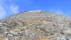 Mont Malamot from south-east. | |
| Highest point | |
| Elevation | 2,917 m (9,570 ft) |
| Prominence | 334 m (1,096 ft) |
| Coordinates | 45°12′05″N 6°54′31″E |
| Geography | |
| Parent range | Cottian Alps |

History
Nowadays entirely included in French territory, it separates the valleys of Dora Riparia and Arc. At the top is a large fortification built by the Italian Regio Esercito in 1889, on two floors, which could house some 200 troops. The area was further fortified in 1932-1940 during the construction of the Alpine Wall.
Sources
- Aruga, R.; Losana, P; A. Re (1985). Alpi Cozie Settentrionali. San Donato Milanese: CAI-TCI.
gollark: Over long enough timescales it's possible. Nothing else works because all power things ever require scarce input.
gollark: Just get more?
gollark: Nuclear fission will certainly not work *literally forever* or even millions of years, but it doesn't have to.
gollark: If I say my reactor is made of 2 tonnes of uranium it's preloaded with, how is that better than that being supplied as fuel?
gollark: The relevant metric is scarce inputs per joule, or something.
This article is issued from Wikipedia. The text is licensed under Creative Commons - Attribution - Sharealike. Additional terms may apply for the media files.