Moléson
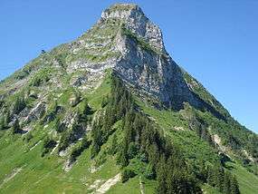
The Moléson (French: Le Moléson) (2,002 metres) is a mountain of the Swiss Prealps, overlooking the region of Gruyères in the canton of Fribourg. It lies at the northern end of the chain between Lake Geneva and the valley of the Sarine.
| Moléson | |
|---|---|
 | |
| Highest point | |
| Elevation | 2,002 m (6,568 ft) |
| Prominence | 512 m (1,680 ft) [1] |
| Parent peak | Rochers de Naye |
| Isolation | 4.68 km (2.91 mi) |
| Coordinates | 46°32′55.6″N 7°1′1.7″E |
| Geography | |
 Moléson Location in Switzerland | |
| Location | Fribourg, Switzerland |
| Parent range | Vaud Alps |
The summit of the mountain can be easily reached, a cable car station being located near the summit at 1,982 metres as well as a meteorological station. From the village of Moléson-sur-Gruyères a funicular leads to Plan Francey (1,517 m), from where the cable car starts.
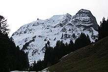
Climate
| Climate data for Le Moléson (1981–2010) | |||||||||||||
|---|---|---|---|---|---|---|---|---|---|---|---|---|---|
| Month | Jan | Feb | Mar | Apr | May | Jun | Jul | Aug | Sep | Oct | Nov | Dec | Year |
| Average high °C (°F) | 0.1 (32.2) |
−0.4 (31.3) |
0.9 (33.6) |
3.3 (37.9) |
8.1 (46.6) |
11.5 (52.7) |
14.3 (57.7) |
14.1 (57.4) |
10.8 (51.4) |
8.2 (46.8) |
3.2 (37.8) |
1.1 (34.0) |
6.3 (43.3) |
| Daily mean °C (°F) | −2.9 (26.8) |
−3.4 (25.9) |
−2.0 (28.4) |
0.3 (32.5) |
4.7 (40.5) |
7.9 (46.2) |
10.5 (50.9) |
10.4 (50.7) |
7.5 (45.5) |
4.9 (40.8) |
0.1 (32.2) |
−2.0 (28.4) |
3.0 (37.4) |
| Average low °C (°F) | −5.7 (21.7) |
−6.2 (20.8) |
−4.8 (23.4) |
−2.4 (27.7) |
2.0 (35.6) |
5.0 (41.0) |
7.4 (45.3) |
7.5 (45.5) |
4.8 (40.6) |
2.2 (36.0) |
−2.6 (27.3) |
−4.9 (23.2) |
0.2 (32.4) |
| Average precipitation mm (inches) | 39 (1.5) |
44 (1.7) |
57 (2.2) |
67 (2.6) |
105 (4.1) |
103 (4.1) |
112 (4.4) |
124 (4.9) |
95 (3.7) |
74 (2.9) |
55 (2.2) |
53 (2.1) |
929 (36.6) |
| Average precipitation days (≥ 1.0 mm) | 8.1 | 7.6 | 10.5 | 10.3 | 13.4 | 12.6 | 11.0 | 11.6 | 10.1 | 9.8 | 8.5 | 9.2 | 122.7 |
| Average relative humidity (%) | 65 | 68 | 75 | 80 | 82 | 83 | 81 | 80 | 80 | 72 | 69 | 66 | 75 |
| Mean monthly sunshine hours | 129 | 134 | 146 | 151 | 153 | 166 | 194 | 187 | 164 | 158 | 124 | 112 | 1,819 |
| Source: MeteoSwiss [2] | |||||||||||||
gollark: What laptop only has 2GB of storage on it?
gollark: It's far below average site size, but I don't know how or why.
gollark: Your thing pulls in an entire Lua VM for about five lines of JS, soooo...
gollark: I think a big reason for inefficiency is that some sites seem obsessed with shipping big images with their content even when it's not meaningful or helpful.
gollark: I've designed my website to be very lightweight, though, so it's reasonably good for people on slow connections and loads very fast.
References
- Retrieved from the Swisstopo topographic maps and Google Earth. The key col is located north of the Dent de Lys at 1,490 metres.
- "Climate Norm Value Tables". Climate diagrams and normals from Swiss measuring stations. Federal Office of Meteorology and Climatology (MeteoSwiss). Archived from the original on 14 May 2013. Retrieved 4 February 2013. The weather station elevation is 1,974 meters above sea level.
External links
This article is issued from Wikipedia. The text is licensed under Creative Commons - Attribution - Sharealike. Additional terms may apply for the media files.