Moel Emoel
Moel Emoel (English: Bare Hill of Emoel) is a hill within the Snowdonia National Park in Gwynedd, North Wales.
| Moel Emoel | |
|---|---|
 | |
| Highest point | |
| Elevation | 549 m (1,801 ft) |
| Prominence | 88 m (289 ft) |
| Parent peak | Foel Goch |
| Listing | Dewey |
| Coordinates | 52.949159°N 3.582153°W |
| Naming | |
| English translation | Bare Hill of Emoel |
| Language of name | Welsh |
| Geography | |
| Location | Gwynedd, Wales |
| Parent range | Arenigs |
| OS grid | SH937402 |
| Topo map | OS Landranger 125 / "Explorer" OL18 |
Location
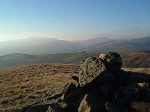
Moel Emoel is a member of the Arenig range with Arenig Fawr lying approximately 7 miles (11 km) to the west. Llyn Celyn can easily be seen between Arenig Fach and Mynydd Nodol. Its parent peak, Foel Goch is 2 miles (3.2 km) northeast, and to the east, the broad ridge of the Berwyn range with Cadair Berwyn lying 10 miles (16 km) away. On a clear day the view southwest towards the nearby town of Bala, 3 miles (4.8 km) away is spectacular. Bala Lake, Aran Benllyn and the distant Cadair Idris form a fine vista. The furthest peak visible is Tarrenhendre, 28 miles (45 km) away near Abergynolwyn.[1]
Ascent
The main route to the summit begins just outside of Bala and takes approximately 3.4 to 4 hours for a round trip. The summit is marked by stone cairn.[2]