Missouri Route 283
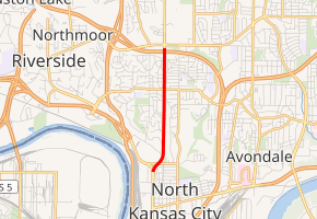
Route 283 is a short highway in the Kansas City, Missouri regional area. Its northern terminus is at Interstate 29 (I-29) and U.S. Route 71 (US 71) in Kansas City; its southern terminus is at Route 9 at the northern city limit of North Kansas City. It is known locally as North Oak Trafficway.
| ||||
|---|---|---|---|---|
| ||||
| Route information | ||||
| Maintained by MoDOT | ||||
| Length | 2.2 mi[1] (3.5 km) | |||
| Major junctions | ||||
| South end | ||||
| North end | ||||
| Highway system | ||||
| ||||

Route description
Route 283 begins at a fork from Route 9 northbound (Burlington Avenue) in North Kansas City. The two routes fork away from one another, with Route 283, the North Oak Trafficway, crossing Northwest 32nd Avenue as a four-lane divided highway. North of Northwest 32nd, Route 283's four lanes come back together and bend northward over a creek as it enters Water Works Park along the southbound side. The route heads due north, becoming commercial northbound and residential southbound. This changes to a long commercial district in Kansas City before intersecting with Northeast Briarcliff Road/Northeast 42nd Street. At that point, the four-lane highway returns to a mixed residential/business stretch until Northeast 46th Street. After Northeast 46th, Route 283 enters an interchange with I-29 and US 71, where the designation terminates at ramps just south of US 69 (Northeast Vivion Road) and Anita B. Gorman Park.[1]
Junction list
The entire route is in Clay County.
| Location | mi[1] | km | Destinations | Notes | |
|---|---|---|---|---|---|
| North Kansas City | 0.0 | 0.0 | Southern terminus of Route 283. | ||
| Kansas City | 2.2 | 3.5 | Northern terminus of Route 283. Exit 1C (Interstate 29 / U.S. Route 71) | ||
| 1.000 mi = 1.609 km; 1.000 km = 0.621 mi | |||||
References
- Microsoft; Nokia (December 8, 2011). "Overview map of Missouri Route 283" (Map). Bing Maps. Microsoft. Retrieved December 8, 2011.