Missolonghi Lagoon
The Missolonghi Lagoon (Greek: Λιμνοθάλασσα Μεσολογγίου, Limnothalassa Mesolongiou) is a shallow lagoon located in the south of Aetolia-Acarnania, Western Greece. It is connected to the Gulf of Patras, a bay of the Ionian Sea. Its length is approximately 15 to 20 km along with its width, its shape resembles a triangle.
| Missolonghi Lagoon | |
|---|---|
| Location | Aetolia-Acarnania |
| Coordinates | 38.3500°N 21.3667°E |
| Type | natural |
| Basin countries | Greece |
| Max. length | 15 to 20 km (9.3 to 12.4 mi) |
| Max. width | 15 km (9.3 mi) |
| Surface area | about 20 to 50 km2 (7.7 to 19.3 sq mi) |
| Max. depth | 9 m (30 ft) |
| Settlements | Missolonghi |
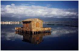
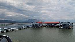
The deepest depth is 5 to 6 m, other than the largest part in which its depths does not pass over half a metre and it contains seaweeds. Several islands surround the lagoon Near to the coasts, the depth is only 10 cm and it is a swampy area that a part of it is land. It features fishes. Strabo called the lake Kynia.
Near the lagoon is the Aitoliko Lagoon to the north. Together they form the Missolonghi–Aitoliko Lagoons complex.
The lagoon was partly drained in the 20th century especially in the western portion in which a part of the land extended southward with farmlands and dikes. The island of Aitoliko or sometimes the peninsula extended by 15 km and 200 m making it the longest extension, the eastern half became a canal and it resembles as a dike.
Islands in Missolonghi lagoon
- Dolmas
- Kleisova
- Komma
- Prokopanistos
- Schinias
- Tourlida
- Vasiladi