Mississippi Highway 923
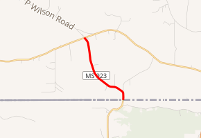
Mississippi Highway 923 (MS 923, also known as MS 584 Spur) is a state highway in southeastern Amite County, Mississippi, United States. The route starts at Louisiana Highway 1053 (LA 1053) on the Louisiana–Mississippi state border and begins traveling northwest. MS 923 ends at MS 584 and continues as P.P. Wilson Road. The route was designated in 1963, after the Mississippi Department of Transportation (MDOT) took over maintenance of the road.
| ||||
|---|---|---|---|---|

MS 923 highlighted in red | ||||
| Route information | ||||
| Maintained by MDOT | ||||
| Length | 2.34 mi[1] (3.77 km) | |||
| Existed | 1963–present | |||
| Major junctions | ||||
| South end | ||||
| North end | ||||
| Location | ||||
| Counties | Amite | |||
| Highway system | ||||
| ||||
Route description
All of MS 923 is located in Amite County.[2] In 2018, MDOT calculated 240 vehicles traveling on MS 923 north of Line Creek Road on average each day.[3] The road is legally defined in Mississippi Code § 65-3-3, as both MS 923 and MS 584 Spur,[4] but it is signed as MS 923.[5] The route is maintained by MDOT as part of the Mississippi State Highway System.[1]
MS 923 begins at the Louisiana–Mississippi state line at the northern terminus of LA 1053. The route travels northward until it intersects Line Creek Road, where it turns northwest. The road travels through a rural part of Amite County, with forests to the west of the route and farmland to the east. MS 923 ends at its intersection with MS 584, and the road continues as P.P. Wilson Road.[6]
History
In 1963, the route of MS 923 was accepted for maintenance by MDOT, and it was paved afterwards.[7] The road was shown on the state highway map by 1964.[8][9]
Major intersections
The entire route is in Amite County.
| Location | mi[1] | km | Destinations | Notes | |
|---|---|---|---|---|---|
| | 0.00 | 0.00 | Continuation into Louisiana | ||
| | 2.34 | 3.77 | |||
| 1.000 mi = 1.609 km; 1.000 km = 0.621 mi | |||||
References
- Mississippi Department of Transportation Planning Division (December 31, 2017). Mississippi Public Roads Selected Statistics Extent, Travel, and Designation (PDF) (Report). Mississippi Department of Transportation. p. 176. Retrieved May 20, 2020.
- Mississippi Department of Transportation (2018). Amite County, Mississippi (PDF) (Map). c. 1:65,000. Jackson: Mississippi Department of Transportation. Retrieved May 20, 2020.
- "MDOT Traffic Count Application". Mississippi Department of Transportation. 2018. Retrieved May 20, 2020.
- Mississippi Legislature. "Sec. 65-3-3: State Highways Designated". Mississippi Code of 1972 as Amended. Mississippi Legislature. Retrieved May 20, 2020 – via LexisNexis.
- Mississippi Department of Transportation (June 2014). Mississippi Highway 923 North (Traffic sign). Osyka: Mississippi Department of Transportation. Retrieved May 20, 2020 – via Google Street View.
- Google (May 7, 2020). "Mississippi Highway 923" (Map). Google Maps. Google. Retrieved May 7, 2020.
- "Re-elect John D. Smith – Highway Commissioner". Enterprise-Journal. McComb, Mississippi. July 26, 1963. p. 7. Retrieved May 20, 2020 – via Newspapers.com.

- Mississippi State Highway Commission (1963). Official Road Map State of Mississippi (PDF) (Map). Jackson: Mississippi State Highway Commission. Retrieved May 20, 2020.
- Mississippi State Highway Commission (1964). Official Road Map State of Mississippi (PDF) (Map). Jackson: Mississippi State Highway Commission. Retrieved May 20, 2020.
External links
![]()
