Mississippi Highway 368
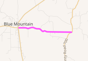
Mississippi Highway 368 (MS 368) is a state highway in northern Mississippi. The route starts at MS 2 and MS 15 in Blue Mountain and travels eastward from the town. The road intersects a few city streets inside the town and county roads outside it. MS 368 ends at its intersection with County Road 700 (CO 700). The route was designated around 1956, connecting MS 2 and MS 15 in Blue Mountain to MS 370 near Dumas. A western extension to MS 5 existed for ten years from 1957 to 1967, and the section east of CO 700 gradually returned to Tippah County for maintenance.
| ||||
|---|---|---|---|---|

MS 368 highlighted in pink | ||||
| Route information | ||||
| Maintained by MDOT and Blue Mountain | ||||
| Length | 3.561 mi[1] (5.731 km) | |||
| Existed | c. 1956–present | |||
| Major junctions | ||||
| West end | ||||
| East end | CO 700 near Blue Mountain | |||
| Location | ||||
| Counties | Tippah | |||
| Highway system | ||||
| ||||
Route description
All of MS 368 is located in southwestern Tippah County.[2] In 2017, the Mississippi Department of Transportation (MDOT) calculated 570 vehicles traveling on MS 368 near CO 711 on average each day.[3] The route is legally defined in Mississippi Code § 65-3-3,[4] and it is maintained by MDOT and the town of Blue Mountain inside the city limits, as part of the Mississippi State Highway System.[1]
MS 368 starts at the intersection of MS 2 (West Palmer Street) and MS 15 (Guyton Boulevard) in Blue Mountain. The route, known as East Palmer Street inside the town, travels eastward through a residential area. At Academy Street, the road comes to an all-way stop. The street continues uphill to Brown Street,[5] where the route leaves the city limits and state maintenance begins.[6][7] MS 368 dips southward briefly near CO 711,[7] and it travels over Bald Knob near CO 708. Past the intersection, the route winds southeastward until it reaches CO 710,[2] and the scenery changes from a forested area to farmland near CO 709.[5] MS 368 continues eastward until it ends at a three-way junction at CO 700.[2]
History
Around 1956, MS 368 was designated onto a gravel road from MS 2 and MS 15 in Blue Mountain to MS 370.[8][9] The route was extended northwestward to MS 5 a year later.[9][10] By 1963, a section of the route near MS 370 became county maintained.[11][12] MS 368 west of Blue Mountain was removed from the state highway system around four years later.[13][14] A part of MS 368 east of Blue Mountain was paved by 1971, [15][16] and the route was truncated from MS 370 to a point west of Dumas by 1998.[17][18] The section from CO 700 to CO 701 was turned over to the Board of Supervisors of Tippah County in July 2002.[19]
Major intersections
The entire route is in Tippah County.
| Location | mi[1] | km | Destinations | Notes | |
|---|---|---|---|---|---|
| Blue Mountain | 0.000 | 0.000 | Western terminus; eastern terminus of western segment of MS 2 | ||
| | 3.561 | 5.731 | CO 700 | Eastern terminus; end of state maintenance | |
| 1.000 mi = 1.609 km; 1.000 km = 0.621 mi | |||||
References
- Mississippi Department of Transportation Planning Division (December 31, 2016). Mississippi Public Roads Selected Statistics Extent, Travel, and Designation (PDF) (Report). Mississippi Department of Transportation. p. 169. Archived from the original (PDF) on June 13, 2018. Retrieved July 16, 2018.
- Mississippi Department of Transportation (2015). Tippah County, Mississippi (PDF) (Map). c. 1:63,360. Jackson: Mississippi Department of Transportation. Retrieved July 16, 2018.
- "MDOT Traffic Count Application". Mississippi Department of Transportation. 2017. Retrieved June 2, 2018.
- Mississippi Legislature. "Sec. 65-3-3: State Highways Designated". Mississippi Code of 1972 as Amended. Mississippi Legislature. Retrieved June 11, 2018 – via LexisNexis.
- Google (July 16, 2018). "Mississippi Highway 368" (Map). Google Maps. Google. Retrieved July 16, 2018.
- Google (July 16, 2018). "East Palmer Street (Mississippi Highway 368) near Blue Mountain corporate limits" (Map). Google Maps. Google. Retrieved July 16, 2018.
- Mississippi Department of Transportation (2011). Blue Mountain, Mississippi (PDF) (Map). c. 1:5,004. Mississippi Department of Transportation. Retrieved July 16, 2018.
- Mississippi State Highway Commission (1955). Official Road Map State of Mississippi (PDF) (Map). Jackson: Mississippi State Highway Commission. Retrieved July 16, 2018.
- Mississippi State Highway Commission (1956). Official Road Map State of Mississippi (PDF) (Map). Jackson: Mississippi State Highway Commission. Retrieved July 16, 2018.
- Mississippi State Highway Commission (1957). Official Road Map State of Mississippi (PDF) (Map). Jackson: Mississippi State Highway Commission. Retrieved July 16, 2018.
- Mississippi State Highway Commission (1962). Road Map State of Mississippi (PDF) (Map). Jackson: Mississippi State Highway Commission. Retrieved July 16, 2018.
- Mississippi State Highway Commission (1963). Official Road Map State of Mississippi (PDF) (Map). Jackson: Mississippi State Highway Commission. Retrieved July 16, 2018.
- Mississippi State Highway Commission (1965). Official Road Map State of Mississippi (PDF) (Map). Jackson: Mississippi State Highway Commission. Retrieved July 16, 2018.
- Mississippi State Highway Department (1967). Official Road Map State of Mississippi (PDF) (Map). Jackson: Mississippi State Highway Department. Retrieved July 16, 2018.
- Mississippi State Highway Department (1970). Official Road Map (PDF) (Map). Jackson: Mississippi State Highway Department. Retrieved July 16, 2018.
- Mississippi State Highway Department (1971). Official Highway Map (PDF) (Map). Jackson: Mississippi State Highway Department. Retrieved July 16, 2018.
- Mississippi Department of Transportation (1996). Official Highway Map of Mississippi (PDF) (Map) (1996–1997 ed.). Jackson: Mississippi Department of Transportation. Retrieved July 16, 2018.
- Mississippi Department of Transportation (1998). Official Highway Map of Mississippi (PDF) (Map). Jackson: Mississippi Department of Transportation. Retrieved July 16, 2018.
- "Deletion from State Highway System: Northern District -- Tippah County". Mississippi Code Annotated § 65-3-139, No. 582 of July 1, 2002. Retrieved July 16, 2018.
