Misa (river in Latvia)
The Misa is a river, 108 kilometres long, in Semigallia, Latvia.[1] Its upper course till tributary Zvirgzde river is rectificated. There are active peat extraction sites and polders on the banks of the river from the village of Stelpe to Beibeži. From the Zvirgzde river to the village of Plakanciems there are several summer cottage colonies on the wooded banks of the Misa. From below Plakanciems to the Misa's confluence with the Iecava near Ozolnieki, the land either side of the river has a relatively high population density.
| Misa | |
|---|---|
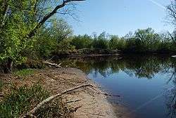 Misa River (right) meets with Iecava river | |
| Location | |
| Country | |
| Physical characteristics | |
| Source | |
| • location | Valle parish, Vecumnieki municipality |
| • elevation | 0.4 m (1 ft 4 in) |
| Mouth | Iecava |
• location | Ozolnieki municipality |
• coordinates | 56.7032°N 23.7822°E |
| Length | 108 km (67 mi) |
| Basin features | |
| Progression | Iecava→ Lielupe→ Baltic Sea |
| Tributaries | |
| • right | Cena |
The biggest settlements near the river are: Stelpe, Beibeži, Dzērumi, Plakanciems, Pēternieki, Dalbe and Ozolnieki.
Tributaries
|
Left bank: Miļļupīte Skujupīte Medaine |
km 11 |
Right bank: Vārnupe Taļķe Zvirgzde Vīksniņa Olaine Cena |
km 17 34 30 14 13 15 |
gollark: Don't they regulate lasers too?
gollark: Why not have moths carry "styropyro" signs around during videos?
gollark: I have a Casio FX-991EX. Casio seems to be more of a thing here. Calculator prices seem kind of ridiculous, though.
gollark: Base64 is really not hard to decode or particularly non-obvious.
gollark: Maybe it's some weird typo code.
References
- Lielāko upju un to baseinu izvietojums Archived 2010-12-27 at the Wayback Machine (The location of the biggest rivers and their basins in Latvia, in Latvian)
| Wikimedia Commons has media related to Misa river. |
This article is issued from Wikipedia. The text is licensed under Creative Commons - Attribution - Sharealike. Additional terms may apply for the media files.