Minnesota State Highway 79
Minnesota State Highway 79 (MN 79) is a 12.128-mile-long (19.518 km) highway in west-central Minnesota, which runs from its intersection with U.S. 59 / State Highway 55 (co-signed) in the city of Elbow Lake and continues east to its eastern terminus at its interchange with Interstate Highway 94/US Highway 52 and Douglas County State-Aid Highway 41 at Evansville Township near Evansville.
| ||||
|---|---|---|---|---|
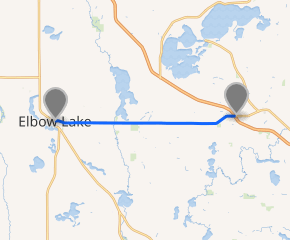
MN 79 highlighted in blue | ||||
| Route information | ||||
| Maintained by MnDOT | ||||
| Length | 12.128 mi[1] (19.518 km) | |||
| Existed | 1933–present | |||
| Major junctions | ||||
| West end | ||||
| East end | ||||
| Location | ||||
| Counties | Grant, Douglas | |||
| Highway system | ||||
| ||||

Route description
State Highway 79 serves as an east–west route in west-central Minnesota between Elbow Lake and Interstate 94/US Highway 52.
The city of Evansville is located immediately east of the junction of Interstate 94/US Highway 52, Highway 79, and County State-Aid Highway 41.
Major intersections
| County | Location | mi[1] | km | Destinations | Notes |
|---|---|---|---|---|---|
| Grant | Elbow Lake | 0.000 | 0.000 | ||
| Douglas | Evansville Township | 12.014– 12.143 | 19.335– 19.542 | I-94 Exit 82 | |
| 1.000 mi = 1.609 km; 1.000 km = 0.621 mi | |||||
gollark: > wearing armor
gollark: It doesn't install fast enough for that to work.
gollark: You can be banned for using HAX to make it not deal damage.
gollark: Yes it does.
gollark: PotatOS's kristminer program.
References
- "Trunk Highway Log Point Listing - Construction District 4" (PDF). Minnesota Department of Transportation. August 23, 2010. Archived from the original (PDF) on December 4, 2008. Retrieved November 2, 2010.
- Riner, Steve. "Details of routes 76–100". The Unofficial Minnesota Highways Page. Self-published. Retrieved November 2, 2010.
This article is issued from Wikipedia. The text is licensed under Creative Commons - Attribution - Sharealike. Additional terms may apply for the media files.