Minnesota State Highway 308
Minnesota State Highway 308 (MN 308) is a short 1.277-mile-long (2.055 km) highway in northwest Minnesota, which runs from its intersection with State Highway 11 in Ross Township (near the unincorporated community of Fox); and continues northbound for 1.3 mile to its northern terminus at its intersection with State Highway 89 in Ross Township. Highway 89 continues north to the Canada–United States border.
| ||||
|---|---|---|---|---|
| 320th Avenue | ||||

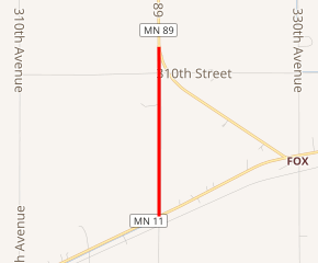
MN 308 highlighted in red | ||||
| Route information | ||||
| Defined by MS § 161.115(239) | ||||
| Maintained by MnDOT | ||||
| Length | 1.277 mi[1] (2.055 km) | |||
| Existed | 1955–present | |||
| Major junctions | ||||
| South end | ||||
| North end | ||||
| Location | ||||
| Counties | Roseau | |||
| Highway system | ||||
| ||||
Route description
Highway 308 is the short west leg of a "Y" joining Highway 11 to Highway 89 northbound. The roadway follows 320th Avenue for 1.3 mile in Roseau County.
The route is legally defined as Route 308 in the Minnesota Statutes.[2]
History
Highway 308 was authorized circa 1955. The route follows a short part of the former alignment of State Highway 89, north of State Highway 11; until a shortcut was constructed for Highway 89, west of the city of Roseau.
The route was paved when it was marked.[3]
Major intersections
The entire route is in Ross Township, Roseau County.
| mi[1] | km | Destinations | Notes | ||
|---|---|---|---|---|---|
| 0.000 | 0.000 | Southern terminus | |||
| 1.277 | 2.055 | Northern terminus | |||
| 1.000 mi = 1.609 km; 1.000 km = 0.621 mi | |||||
References
- "Trunk Highway Log Point Listing - Construction District 2" (PDF). Minnesota Department of Transportation. August 23, 2010. Archived from the original (PDF) on December 4, 2008. Retrieved January 28, 2011.
- "161.115, Additional Trunk Highways". Minnesota Statutes. Office of the Revisor of Statutes, State of Minnesota. 2010. Retrieved January 28, 2011.
- 1956 Official Road Map of Minnesota (Map). Cartography by The H.M. Gousha Company. Minnesota Department of Highways. 1956. § D2. Archived from the original on August 25, 2011. Retrieved January 28, 2011.
