Minnesota State Highway 248
Minnesota State Highway 248 (MN 248) is a 11.219-mile-long (18.055 km) highway in southeast Minnesota, which runs from its intersection with Winona County Road 33 in Altura east to its terminus at its intersection with U.S. Highway 61 just north of Minnesota City, near Winona.
| ||||
|---|---|---|---|---|
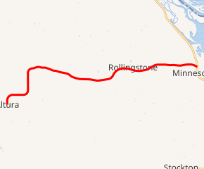
MN 248 highlighted in red | ||||
| Route information | ||||
| Defined by MS § 161.115(179) | ||||
| Maintained by MnDOT | ||||
| Length | 11.219 mi (18.055 km) | |||
| Existed | July 1, 1949[1]–present | |||
| Major junctions | ||||
| West end | ||||
| East end | ||||
| Location | ||||
| Counties | Winona | |||
| Highway system | ||||
| ||||

Route description
Highway 248 serves as an east–west route in southeast Minnesota between Altura, Rollingstone, and Minnesota City.
Highway 248 is also known as Main Street in Altura.
The route passes through the Richard J. Dorer State Forest.
The route is legally defined as Route 248 in the Minnesota Statutes.[2]
Major intersections
The entire route is in Winona County.
| Location | mi | km | Destinations | Notes | |
|---|---|---|---|---|---|
| Altura | 0.000 | 0.000 | |||
| Rollingstone Township | 11.222 | 18.060 | |||
| 1.000 mi = 1.609 km; 1.000 km = 0.621 mi | |||||
gollark: I don't like C either.
gollark: `nasm`
gollark: They would fly around between computers doing bee things.
gollark: We should make electronic bees.
gollark: what ifBEESin computers?
References
- "Chapter 663-H.F. No. 1792", Session Laws of Minnesota for 1949, Earl L. Berg, Commissioner of Administration, pp. 1177–1185
- "161.115, Additional Trunk Highways". Minnesota Statutes. Office of the Revisor of Statutes, State of Minnesota. 2010. Retrieved December 29, 2010.
- Minnesota 1950 Official Highway Map (Map). Minnesota Department of Highways. January 1, 1950. § Q21. Archived from the original on July 21, 2011. Retrieved December 29, 2010.
External links
This article is issued from Wikipedia. The text is licensed under Creative Commons - Attribution - Sharealike. Additional terms may apply for the media files.