Minnesota State Highway 246
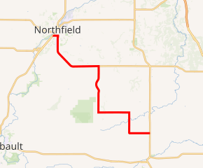
Minnesota State Highway 246 (MN 246) is a 18.221-mile-long (29.324 km) highway in southeast Minnesota, which runs from its intersection with State Highway 3 in the city of Northfield and continues south and east to its eastern terminus at its intersection with State Highway 56 in Holden Township near Kenyon.
| ||||
|---|---|---|---|---|

MN 246 highlighted in red | ||||
| Route information | ||||
| Maintained by MnDOT | ||||
| Length | 18.221 mi (29.324 km) | |||
| Existed | July 1, 1949[1]–present | |||
| Major junctions | ||||
| West end | ||||
| East end | ||||
| Location | ||||
| Counties | Rice, Goodhue | |||
| Highway system | ||||
| ||||
Route description
Highway 246 serves as an east–west and a north–south route between the communities of Northfield, Dennison, Nerstrand, and Kenyon in southeast Minnesota. It follows a zigzag route running along section lines.
In the city of Northfield, Highway 246 follows Woodley Street W. and Division Street S.
Highway 246 passes near the town of Dennison at its junction with County Road 31.
The route is also known as Main Street in Nerstrand.
Nerstrand-Big Woods State Park is located near the junction of Highway 246 and Rice County Road 29 at Nerstrand. The park entrance is located on County Road 29.[2]
The route is legally defined as Routes 246 and 320 in the Minnesota Statutes.[3] It is not marked with the latter number.
History
Highway 246 was authorized in 1949 between then-U.S. 65 at Northfield and Nerstrand. This original portion of the route was paved in 1956.[4][5]
In 1959, the highway was extended east of Nerstrand to State Highway 56 in Holden Township near Kenyon.[6] This segment was paved in the late 1970s.[7][8]
Major intersections
| County | Location | mi | km | Destinations | Notes |
|---|---|---|---|---|---|
| Rice | Northfield | 0.000 | 0.000 | ||
| 0.494 | 0.795 | ||||
| 1.028– 1.034 | 1.654– 1.664 | Jefferson Parkway | Four-way stop | ||
| Northfield Township | 1.987 | 3.198 | |||
| 2.122 | 3.415 | ||||
| 3.492 | 5.620 | ||||
| 6.708 | 10.795 | ||||
| Wheeling Township | 10.231 | 16.465 | |||
| 11.310 | 18.202 | ||||
| Nerstrand | 12.307 | 19.806 | |||
| Goodhue | Holden Township | 18.320 | 29.483 | CSAH 30 continues to Wanamingo | |
| 1.000 mi = 1.609 km; 1.000 km = 0.621 mi | |||||
References
- "Chapter 663-H.F. No. 1792", Session Laws of Minnesota for 1949, Earl L. Berg, Commissioner of Administration, pp. 1177–1185
- Minnesota DNR website for Nerstrand-Big Woods State Park
- "161.115, Additional Trunk Highways". Minnesota Statutes. Office of the Revisor of Statutes, State of Minnesota. 2010. Retrieved December 29, 2010.
- 1956 Official Road Map of Minnesota (Map). Cartography by The H.M. Gousha Company. Minnesota Department of Highways. 1956. § K17-K18. Archived from the original on August 25, 2011. Retrieved December 29, 2010.
- 1957 Official Road Map of Minnesota (Map). Cartography by The H.M. Gousha Company. Minnesota Department of Highways. 1957. § K17-K18. Archived from the original on August 25, 2011. Retrieved December 29, 2010.
- "Chapter 426-H. F. No. 299" (PDF). Session Laws of Minnesota for 1959. April 24, 1959. pp. 563–565.
- 1977-78 Official Highway Map of Minnesota (Map). Minnesota Department of Transportation. 1977. § K19. Retrieved December 29, 2010.
- 1979-1980 Official Transportation Map of Minnesota (Map). Minnesota Department of Transportation. 1979. § K19. Retrieved December 29, 2010.
