Mingachevir Dam
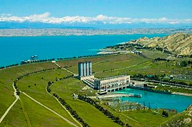
The Mingachevir Dam (Mingachevir Hydro Power Station) is the largest hydroelectric power station in the South Caucasus, is located over Kur river and not far from Mingachevir city.
| Mingachevir Dam | |
|---|---|
 Dam and reservoir | |
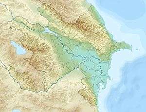
 Location of Mingachevir Dam in Azerbaijan | |
| Country | Azerbaijan |
| Location | Mingachevir |
| Coordinates | 40°47′24″N 47°1′42″E |
| Purpose | Power, irrigation |
| Status | Operational |
| Construction began | 1945 |
| Opening date | 1953 |
| Dam and spillways | |
| Type of dam | Embankment, earth-fill |
| Impounds | Kura River |
| Height | 80 m (260 ft) |
| Length | 1,550 m (5,090 ft) |
| Reservoir | |
| Creates | Mingachevir reservoir |
| Total capacity | 15.730 km3 (12,753,000 acre⋅ft) |
| Active capacity | 9 km3 (7,300,000 acre⋅ft) |
| Surface area | 605 km2 (234 sq mi) |
| Maximum length | 70 km (43 mi) |
| Operator(s) | Azerenerji |
| Commission date | 1953/2000 |
| Type | Conventional |
| Hydraulic head | 65 m (213 ft) |
| Turbines | 6 x 70 MW Francis-type |
| Installed capacity | 420 MW (560,000 hp) |
History
The construction of the station started in 1945, the first hydro aggregate was put into operation in 1953. In 1954, the station was put into operation with full capacity. President of the Republic of Azerbaijan participated in the ceremony of commissioning of Mingachevir hydroelectric power station after reconstruction on February 27, 2018. All hydro generators and hydro turbines of the station were replaced with new ones within the framework of the reconstruction. As a result, the production capacity of the power station was increased from 284 MW to 424 MW. [1]
A large number of people came from different regions of Azerbaijan due to the installation of Mingachevir hydroelectric power station. In total 20,000 people took part in the construction of the power station. Approximately 10,000 German prisoners of the military were involved in the installation towards the end of the 1940s. [1]
The dam serves several purposes to include hydroelectric power production and water storage for irrigation.[2] Mingachevir reservoir, behind the dam, supplies water to the Upper Qarabag and Upper Sirvan Channels which help irrigate about 1,000,000 ha (2,500,000 acres) of farmland in the country. Its six Francis turbine-generators were overhauled or replaced with 70 megawatts (94,000 hp) sets in 2000.[3] Mingachevir reservoir has a storage capacity of 15.730 cubic kilometres (12,753,000 acre⋅ft), covering 605 km2 (234 sq mi). The length of the dam is 1,550 metres (5,090 ft), its width is 16 metres (52 ft) and height is 80 m (260 ft).[4]
Technical parameters
The capacity of the Mingachevir HPP is 359 MW which has 6 hydroaggregats. Average annual electric power production is 1.4 billion kW / hr.
Water intersection includes concrete dam consisting of 3 holes (width of 30 m with an open channel), water intake facility to pressured water pipes consisting of 6 holes (length of 66 m), dam of land (Length 1550 m, height 80 m), device with 1 hole that intakes water to Upper Garabagh and Upper Shirvan canal. [5]
See also
References
- Official web-site of President of Azerbaijan Republic. "Ilham Aliyev launched newly-renovated Mingachevir Hydroelectric Power Station". en.president.az. Retrieved 2018-06-30.
- "Energy production". AzerEnerji. Retrieved 12 March 2015.
- "Hydroelectric Plants in the CIS - other countries". IndustCards. Archived from the original on 19 July 2009. Retrieved 12 March 2015.
- "Azerenerji Hydropower Optimization Project" (PDF). United Nations CDM. p. 4. Retrieved 12 March 2015.
- "Mingachevir Dam" (in Azerbaijani).
External links