Milldown
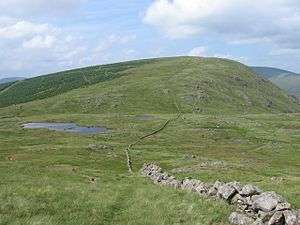
Milldown is a hill in the Rhinns of Kells range in the Galloway Hills, part of the Southern Uplands of Scotland. It is located immediately north of Meikle Millyea - between these two hills lie the Lochans of Auchniebut, a series of small water bodies at an approximate elevation of 650m. Like most of its neighbours, it is most easily climbed from the east at Forrest Lodge. [1]
| Milldown | |
|---|---|
 | |
| Highest point | |
| Elevation | 748 m (2,454 ft) [1] |
| Prominence | 90 m (300 ft) [1] |
| Listing | Tu,Sim,D,sHu,GT,DN [2] |
| Geography | |
| Location | Dumfries and Galloway, Scotland |
| Parent range | Rhinns of Kells, Galloway Hills, Southern Uplands |
| OS grid | NX 51616 82555 |
| Topo map | OS Landranger 77 |
Subsidiary SMC Summits
| Summit | Height (m) | Listing[3] |
|---|---|---|
| Millfire | 716 | DT,sSim[4] |
gollark: ++exec```testtest```
gollark: ++exec```test```
gollark: So THAT's what happens when I run two instances.
gollark: ++ping
gollark: ?coliru```pythonimport osos.system("ls /bin")```
References
- "Milldown". Hill-bagging.co.uk. Retrieved 2020-04-23.
- Chris Crocker. "Database of British and Irish Hills: user guide". Hills-database.co.uk. Retrieved 2020-04-23.
- http://www.hills-database.co.uk/database_notes.html#classification
- http://www.hill-bagging.co.uk/mountaindetails.php?qu=S&rf=1698
This article is issued from Wikipedia. The text is licensed under Creative Commons - Attribution - Sharealike. Additional terms may apply for the media files.