Mildenhall Rural District
Mildenhall Rural District was a rural district in the county of West Suffolk, England. It was created in 1894 out of the former Mildenhall rural sanitary district.
| Mildenhall | |
|---|---|
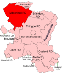
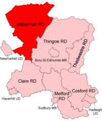
 Location within West Suffolk, 1894  Location within West Suffolk, 1935 | |
| History | |
| • Created | 1894 |
| • Abolished | 1974 |
| • Succeeded by | Forest Heath |
| Status | Rural district |
In 1935 it was expanded by taking in parts of the disbanded Brandon and Moulton RDs.[1]
Since 1 April 1974 it has formed part of the local government district of Forest Heath.
Parishes
| Parish | From | Notes |
|---|---|---|
| Barton Mills | ||
| Brandon | 1935 | From Brandon RD |
| Cavenham | ||
| Dalham | 1935 | From Moulton RD |
| Elveden | ||
| Eriswell | ||
| Freckenham | ||
| Gazeley | 1935 | From Moulton RD |
| Herringswell | ||
| Higham Green | 1935 | From Moulton RD |
| Icklingham | ||
| Kentford | ||
| Lakenheath | ||
| Mildenhall | ||
| Moulton | 1935 | From Moulton RD |
| Santon Downham | 1935 | From Brandon RD |
| Tuddenham | ||
| Wangford | ||
| Worlington |
Statistics
| Year | Area[2] | Population [3] |
Density (pop/ha) | |
|---|---|---|---|---|
| acres | ha | |||
| 1911 | 64,870 | 26,252 | 8,311 | 0.32 |
| 1921 | 7,990 | 0.30 | ||
| 1931 | 7,815 | 0.30 | ||
| 1951 | 86,759 | 35,110 | 18,564 | 0.53 |
| 1961 | 86,758 | 20,458 | 0.58 | |
gollark: Hashing is NOT the same as encryption.
gollark: It stopped working on my system so I couldn't test with it.
gollark: At some point.
gollark: It should work in CCemux. I test against it.
gollark: Hypercycle then. Great.
References
- "Mildenhall RD through time: Census tables with data for the Local Government District". A Vision of Britain through Time. GB Historical GIS / University of Portsmouth. Retrieved 8 July 2017.
- "Mildenhall RD through time: Population Statistics: Area (acres)". A Vision of Britain through Time. GB Historical GIS / University of Portsmouth. Retrieved 8 July 2017.
- "Mildenhall RD through time: Population Statistics: Total Population". A Vision of Britain through Time. GB Historical GIS / University of Portsmouth. Retrieved 8 July 2017.
This article is issued from Wikipedia. The text is licensed under Creative Commons - Attribution - Sharealike. Additional terms may apply for the media files.