Middle Fork Flathead River
The Middle Fork Flathead River is a 92-mile (148 km)[2] river in western Montana in the United States, forming the southwestern boundary of Glacier National Park. Its drainage basin lies to the east of the South Fork Flathead River and the Hungry Horse Reservoir. Towns along the river include West Glacier, Nyack, Pinnacle, Essex, and Nimrod.[1]
| Middle Fork Flathead River | |
|---|---|
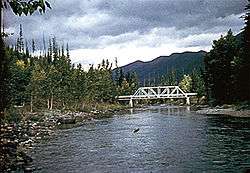 The river near Essex, Montana | |
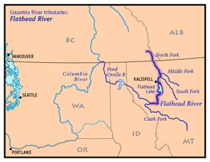 Map of the Flathead River watershed showing the Middle Fork | |
| Location | |
| Country | United States |
| State | Montana |
| Cities | West Glacier, Montana, Essex, Montana |
| Physical characteristics | |
| Source | Bob Marshall Wilderness |
| • location | Montana, United States |
| • coordinates | 47°59′47″N 113°03′30″W[1] |
| Mouth | Flathead River |
• location | Montana, United States |
• coordinates | 48°28′01″N 114°04′09″W[1] |
• elevation | 3,120 ft (950 m) |
| Length | 92 mi (148 km)[2] |
| Basin size | 1,160 sq mi (3,000 km2) |
| Discharge | |
| • location | West Glacier, 3.8 miles (6.1 km) above the mouth |
| • average | 2,854 cu ft/s (80.8 m3/s) |
| • minimum | 189 cu ft/s (5.4 m3/s) |
| • maximum | 140,000 cu ft/s (4,000 m3/s) |
The river's headwaters lie in the Bob Marshall Wilderness at the confluence of two small streams, Strawberry Creek and Bowl Creek.[3] From there, it runs north, receiving many tributaries from glacial valleys to the east and west, most of them inside Glacier National Park. The river begins to parallel U.S. Highway 2 as it winds north-northwest, and after a long and narrow course, the river enters a wider valley and begins to spread out and braid between meadows and forested slopes. It then enters another narrow gorge, turning generally westwards, then passing the southwestern entrance of the national park, receives a tributary from Lake McDonald, a large glacial lake to the north, from the right. The river then proceeds southwest to meet the North Fork Flathead River, southwest of West Glacier and northeast of Columbia Falls, forming the main stem of the Flathead River, which eventually flows into the Clark Fork River (the Pend Oreille River).[4]
See also
References
- "Middle Fork Flathead River". Geographic Names Information System. United States Geological Survey. 4 April 1980. Retrieved 2009-08-29.
- Fischer, Carol (1990). Paddling Montana. Globe Pequot. pp. 61, 67–69, 72–74, 78–79. ISBN 978-1-56044-589-0.
- "Middle Fork of the Flathead River". U.S. Forest Service. www.fs.fed.us. Retrieved 2009-08-29.
- Woessner, William; Potts, Donald F.; Running, Steven W.; Kimball, John S.; DeLuca, Thomas H.; Fagre, Daniel B.; Makepeace, Seth; Hendrix, Marc S.; Johnnie, N. Moore; Lorang, Mark S.; Ellis, Bonnie K. (30 July 2004). "Flathead River Basin Hydrologic Observatory, Northern Rocky Mountains" (PDF). Consortium of Universities for the Advancement of Hydrologic Science. www.cuahsi.org. Archived from the original (PDF) on 27 June 2006. Retrieved 2009-08-29.