Mesa de los Tres Reyes
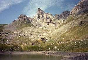
Mesa de los Tres Reyes (Basque: Hiru Erregeen Mahaia, Roncalese Basque: Iror Errege Maia, Aragonese: Meseta d'os Tres Reis, Gascon: Tabla d'eths Tros Rouyes, French: Table des Trois Rois) is a mountain of the Pyrenees. It is the highest point of Spanish Navarre, with an elevation of 2,428 metres (7,966 ft).
| Mesa de los Tres Reyes | |
|---|---|
 Mesa de los Tres Reyes viewed from Lac de Lhurs. | |
| Highest point | |
| Elevation | 2,428 m (7,966 ft) |
| Prominence | 392 m (1,286 ft) |
| Coordinates | 42°56′42″N 0°43′20″W |
| Naming | |
| English translation | Table of the Three Kings |
| Language of name | Spanish |
| Geography | |
 Mesa de los Tres Reyes Location in Spain, on the border with France | |
| Location | Aragon/Navarre, Spain; France |
| Parent range | Pyrenees |
Its name, "The Table of the Three Kings", derives from the fact that the mountain is located at the confluence of the ancient kingdoms of Navarre, Aragon, and Béarn; where the three kings of those kingdoms met from time to time to discuss matters of importance.
See also
External links
- "Mesa de los Tres Reyes" on Summitpost
- (in French) Mesa de los Tres Reyes, CamptoCamp.
This article is issued from Wikipedia. The text is licensed under Creative Commons - Attribution - Sharealike. Additional terms may apply for the media files.