Stadtlengsfeld
Stadtlengsfeld is a town and a former municipality in the Wartburgkreis district of Thuringia, Germany. Since 1 January 2019, it is part of the municipality Dermbach. It is situated in the Rhön Mountains, 8 km southwest of Bad Salzungen.
Stadtlengsfeld | |
|---|---|
Ortsteil of Dermbach | |
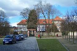 Lengsfeld Castle | |
 Coat of arms | |
Location of Stadtlengsfeld 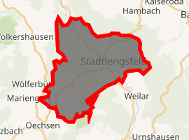
| |
 Stadtlengsfeld  Stadtlengsfeld | |
| Coordinates: 50°46′59″N 10°7′59″E | |
| Country | Germany |
| State | Thuringia |
| District | Wartburgkreis |
| Municipality | Dermbach |
| Area | |
| • Total | 27.61 km2 (10.66 sq mi) |
| Elevation | 272 m (892 ft) |
| Population (2017-12-31) | |
| • Total | 2,356 |
| • Density | 85/km2 (220/sq mi) |
| Time zone | CET/CEST (UTC+1/+2) |
| Postal codes | 36457 |
| Dialling codes | 036965 |
| Vehicle registration | WAK |
| Website | www.stadt-stadtlengsfeld.eu |
History
Within the German Empire (1871-1918), Stadtlengsfeld was part of the Grand Duchy of Saxe-Weimar-Eisenach.
It was the site of the Menzengraben mining accident in 1953.
Sister cities
gollark: <@!293066066605768714> Do you want an "m3u" file?
gollark: How is it APIONET's fault?
gollark: I wondered how long it would be before anyone noticed.
gollark: Yes, the OIR™ backend is now locked down™ with advanced HTTP basic authentication.
gollark: Although, being internet-based, it's not actually *broadcasting* without anyone connected, although it is encoding.
External links
![]()
References
- "Testvértelepülések". Retrieved 30 April 2014.

| Authority control |
|
|---|
This article is issued from Wikipedia. The text is licensed under Creative Commons - Attribution - Sharealike. Additional terms may apply for the media files.