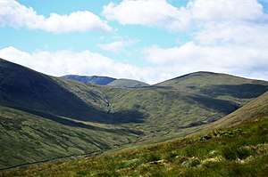
Meaul
Meaul is a hill in the Rhinns of Kells range in the Galloway Hills, part of the Southern Uplands of Scotland. It is climbed from a number of directions; most commonly from Garryhorn near Carsphairn, often as part of a complete traverse of the ridge.[1]
| Meaul | |
|---|---|
 | |
| Highest point | |
| Elevation | 695 m (2,280 ft) [1] |
| Prominence | 74 m (243 ft) [1] |
| Listing | Tu,Sim,D,GT,DN [2] |
| Geography | |
| Location | Dumfries and Galloway, Scotland |
| Parent range | Rhinns of Kells, Galloway Hills |
| OS grid | NX 50063 90978 |
| Topo map | OS Landranger 77 |
Subsidiary SMC Summits
| Summit | Height (m) | Listing[3] |
|---|---|---|
| Bow | 613 | Tu,Sim,DT,GT,DN[4] |
gollark: If you mean the italic one, it's the constant e, probably.
gollark: I don't know what you're referring to. Photograph it?
gollark: Integration.
gollark: Besides, everyone needs you need progressive overload to increase in strength, not just a fixed weight.
gollark: They don't actually weigh that much in absolute terms so it wouldn't do much.
References
- "Meaul". www.hill-bagging.co.uk. Retrieved 23 April 2020.
- "Database of British and Irish Hills: user guide". www.hills-database.co.uk. Retrieved 23 April 2020.
- http://www.hills-database.co.uk/database_notes.html#classification
- https://www.hill-bagging.co.uk/mountaindetails.php?qu=S&rf=1714
This article is issued from Wikipedia. The text is licensed under Creative Commons - Attribution - Sharealike. Additional terms may apply for the media files.